![]()
![]()
![]()
![]()
Where to stay and
what to do in
Glacier
The town and road map of Washington's Cascades will help you locate cities, towns, attractions and points of interest.
Nearby Cities and Towns
Abbotsford BC, 27 miles
Bellingham WA, 35
miles
Concrete WA, 64 miles
Langley BC, 38 miles
Maple Falls WA, 8 miles
Cities and Towns of the North Cascades
North Cascades Visitor Information
More Cascades
North Cascades
Central Cascades
South Cascades
Washington Travel Regions and Maps
Map
Cascade Mountains
Map
Northeast
Map
Northwest
Map
Olympic Peninsula
Map
Puget Sound
Map
San Juan Islands
Map
South Central
Map
Southeast
Map
Southwest
Glacier, Washington
Description
Glacier is a gateway community for the Mount Baker area and is the last outpost on the Mount Baker Highway before entering the national forest. The community caters to summer hikers and river rafters, and winter skiers and snowboarders. While Glacier offers food and lodging, there is no gas available, so you will need to return to Maple Falls for fuel.
Location
Nestled in a beautiful valley, Glacier is just inside the Mount Baker National Recreation Area, and north of the Mount Baker Wilderness Area. The community is about 24 miles west of the Mount Baker Ski Area, and about 32 miles east of the intersection of I-5 and State Route 542 in Bellingham.
Getting to Glacier
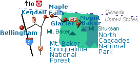 The
only route to Glacier is State Route 542, otherwise known as the Mount Baker
Highway. Turn east from the town of Bellingham on I-5. The section of SR 542
from Glacier to Artist Point, where it terminates 24 miles past Glacier, was
designated a National Forest Scenic Byway in 1989.
The
only route to Glacier is State Route 542, otherwise known as the Mount Baker
Highway. Turn east from the town of Bellingham on I-5. The section of SR 542
from Glacier to Artist Point, where it terminates 24 miles past Glacier, was
designated a National Forest Scenic Byway in 1989.
History
Gold mining followed by coal mining, logging and some remote agricultural activity fostered the development of a community here. By the turn of the century, outdoor enthusiasts were already coming to the area, and so began the town's happy relationship with tourism. The town prospered enough to make it worth the while of the Bellingham Bay and British Columbia Railroad to reach here in 1904. In 1906, the town site became part of the National Forest, but prior-established homesteaders were given deeds to their lands and mining claims were honored. In 1915, the town had three hotels, a mercantile store, town hall, pool hall, barber shop, livery stable and a few quietly operated brothels. When the Mount Baker Highway was opened in 1923, the once-remote area was made accessible to the motoring public.
![]()
Go Northwest!
Bookstore
Best selection of books on the Northwest.
Click here!
 Moon
Washington, 11th Edition (Moon Handbooks) by Matthew Lombardi. This
travel writer and Seattle resident gives an insider's view of everything
the Evergreen State has to offer such as great places to eat, scenic
drives and volunteer vacations. Discover Seattle's arts and culture,
details on climbing Mt Rainier and so much more.
Order now...
Moon
Washington, 11th Edition (Moon Handbooks) by Matthew Lombardi. This
travel writer and Seattle resident gives an insider's view of everything
the Evergreen State has to offer such as great places to eat, scenic
drives and volunteer vacations. Discover Seattle's arts and culture,
details on climbing Mt Rainier and so much more.
Order now...
 Frommer's Washington State,
7th Edition by Karl Samson. This expert author tells you where to find great places to stay in every price range,
the best outdoor recreation and much more. Utilize the planning tools to
maximize your next adventure in the Evergreen State.
Order now...
Frommer's Washington State,
7th Edition by Karl Samson. This expert author tells you where to find great places to stay in every price range,
the best outdoor recreation and much more. Utilize the planning tools to
maximize your next adventure in the Evergreen State.
Order now...
 Wild
Roads Washington: 80 Scenic Drives to Camping, Hiking Trails, and Adventures
by Seabury Blair Jr. This adventure guidebook details the forest roads of
Washington with information on hikes off each route as well as driving
routes that provide scenic vistas almost as good as those reached by foot.
Order now...
Wild
Roads Washington: 80 Scenic Drives to Camping, Hiking Trails, and Adventures
by Seabury Blair Jr. This adventure guidebook details the forest roads of
Washington with information on hikes off each route as well as driving
routes that provide scenic vistas almost as good as those reached by foot.
Order now...
We appreciate your orders. They help keep
Go Northwest! online.
Northwest Books
from . . .
![]()
Shopping at
Go Northwest!
![]()
![]()
![]()
![]()