![]()
![]()
![]()
![]()
Where to stay and
what to do in
Holly
Washington State Ferry Service
Schedules
Route Map
Weather
Washington Travel Regions and Maps
Map
Cascade Mountains
Map
Northeast
Map
Northwest
Map
Olympic Peninsula
Map
Puget Sound
Map
San Juan Islands
Map
South Central
Map
Southeast
Map
Southwest
Holly, Washington
Holly, at the end of the Seabeck-Holly Road has views of Hood Canal, the Olympic Mountains and sunsets and with an average of 68" of rain a year is the greenest corner of the Kitsap Peninsula. A waterside residential community with about 60 families (nearly half summer residents) and no commercial establishments where little has changed in 20 or 30 years.
Around Holly you'll find majestic cedar, fir, maple, and wild cherry trees. Raccoons, foxes, coyotes, eagles, ospreys, dear, owls and eagles are common with bear, bobcat, otter and cougars sightings more rare. The streams, Anderson creek and Holly creek, have the purest water because there is so little development.
|
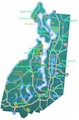
The Puget Sound town and road map will help you locate cities, towns and other attractions. |
Go Northwest!
Bookstore
Best selection of books on the Northwest.
Click here!
 Moon
Washington, 11th Edition (Moon Handbooks) by Matthew Lombardi. This
travel writer and Seattle resident gives an insider's view of everything
the Evergreen State has to offer such as great places to eat, scenic
drives and volunteer vacations. Discover Seattle's arts and culture,
details on climbing Mt Rainier and so much more.
Order now...
Moon
Washington, 11th Edition (Moon Handbooks) by Matthew Lombardi. This
travel writer and Seattle resident gives an insider's view of everything
the Evergreen State has to offer such as great places to eat, scenic
drives and volunteer vacations. Discover Seattle's arts and culture,
details on climbing Mt Rainier and so much more.
Order now...
 Frommer's Washington State,
7th Edition by Karl Samson. This expert author tells you where to find great places to stay in every price range,
the best outdoor recreation and much more. Utilize the planning tools to
maximize your next adventure in the Evergreen State.
Order now...
Frommer's Washington State,
7th Edition by Karl Samson. This expert author tells you where to find great places to stay in every price range,
the best outdoor recreation and much more. Utilize the planning tools to
maximize your next adventure in the Evergreen State.
Order now...
We appreciate your orders. They help keep
Go Northwest! online.
Northwest Books
from . . .
![]()
Shopping at
Go Northwest!
![]()
![]()
![]()
![]()