Where to stay
and
what to do in
Mount Rainier NP
ACCOMMODATIONS
Inside the Park
Outside the Park
ATTRACTIONS
Museums
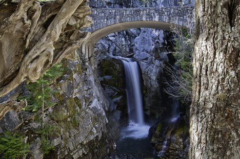
Scenic Sites
More Mount Rainier
Description of Park
History of Park
Map of Area
Map of Park
Rainier the Mountain
Links
Nearby Cities and Towns
Ashford, 23 miles
Auburn, 62 miles
Buckley, 59 miles
Crystal Mountain, 46 miles
Eatonville, 44 miles
Elbe, 31 miles
Enumclaw, 63 miles
Greenwater, 19 miles
Mineral, 19 miles
Morton, 30 miles
Packwood, 29 miles
Randle, 48 miles
Tacoma, 60 miles
Yakima, 74 miles
More
Volcanoes
More Cascades
North Cascades
Central Cascades
South Cascades
Washington Travel Regions and Maps
Map
Cascade Mountains
Map
Northeast
Map
Northwest
Map
Olympic Peninsula
Map
Puget Sound
Map
San Juan Islands
Map
South Central
Map
Southeast
Map
Southwest
Mount Rainier
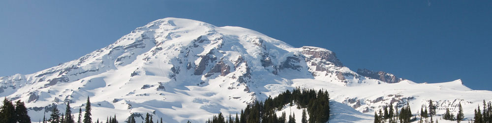
Mt. Rainier, the highest of the volcanoes in the Washington Cascade Mountains and the centerpiece of Mount Rainier National Park, certainly dominates the skyline around western Washington. It is a relatively young volcano, being over ten million years younger than the surrounding ranges.


What makes Mount Rainier particularly unique, from a geographical perspective, is the 36 miles of glaciers covering the mountain. This collection of ice is the largest remnant of the Ice Age to be found on one mountain (a "single-peak glacier system") in the world. Glaciers are formed from snow that does not melt from year to year. Instead it accumulates to such depths that air is pressed out and the snow is compressed to ice. The ice gradually moves down the mountainside under the force of gravity.
The glacial valleys, sometimes gouging over thousand feet into the sides of Rainier, visually accentuate the height of the mountain. Drainage from the volcano manages to find its way into five major rivers.
Although it is an object of admiration and even affection amongst locals, Mount Rainier is considered the most dangerous volcano in the range. In fact, Mount Rainier has the status of being one of sixteen volcanoes worldwide to be designated a "Decade Volcano" in a United Nations program aimed at better utilizing science and emergency management to reduce the severity of natural disasters.
An eruption could affect the large nearby population, sending Rainier's huge volume of ice, snow and earth into the area. Rainier also presents the hazard of avalanches and debris flows during its inactive period. A mudflow caused by steam explosions about 5,700 years ago was one of the largest known in the world. This eruption reduced the height of Rainier by over 1,500 feet and sent a wall of mud 100 feet high, cascading like a river of wet cement as far as the waters of Puget Sound. The towns of Auburn, Kent, Puyallup and Sumner are built on top of this flow. About 30 earthquakes occur under Mount Rainier per year, making it the most seismically active volcano in the Cascade Range after Mount St. Helens.
|
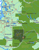
To locate cities and towns near Mount Rainier National Park go to our Map of Nearby Cities and Towns by clicking above map image. |
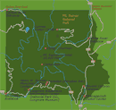
Click on Mount Rainier National Park Map to locate park features such as campgrounds, roads and visitor centers. |
Go Northwest!
Bookstore
Best selection of books on the Northwest.
Click here!
 Mt.
Rainier: Adventures and Views by John Harlin III and James Martin. Photographer James Martin
captures the awesome beauty of this majestic peak, from its icy glaciers to
its lush alpine meadows, while climber and writer John Harlin provides
engrossing accounts of adventure on the mountain.
Order now...
Mt.
Rainier: Adventures and Views by John Harlin III and James Martin. Photographer James Martin
captures the awesome beauty of this majestic peak, from its icy glaciers to
its lush alpine meadows, while climber and writer John Harlin provides
engrossing accounts of adventure on the mountain.
Order now...
 Washington's
Mount Rainier National Park: A Centennial Celebration by Tim McNulty
(Author) and
Pat O'Hara (Photographer). This book lets you see the mountain
through all its facets, such as the geologic and climatic forces that continue
to shape it, the rich legacy of humans' relationship with it and its
delicate ecosystems.
Order now...
Washington's
Mount Rainier National Park: A Centennial Celebration by Tim McNulty
(Author) and
Pat O'Hara (Photographer). This book lets you see the mountain
through all its facets, such as the geologic and climatic forces that continue
to shape it, the rich legacy of humans' relationship with it and its
delicate ecosystems.
Order now...
 Adventure
Guide to Mount Rainier: Hiking, Climbing and Skiing in Mt. Rainier National
Park by Jeff Smoot. Includes descriptions of tourist trails, nature
trails, off-trail hiking, bike routes, minor peak scrambling, skiing and
snowshoeing areas, and of course, summit routes.
Order now...
Adventure
Guide to Mount Rainier: Hiking, Climbing and Skiing in Mt. Rainier National
Park by Jeff Smoot. Includes descriptions of tourist trails, nature
trails, off-trail hiking, bike routes, minor peak scrambling, skiing and
snowshoeing areas, and of course, summit routes.
Order now...
 Mount
Rainier: A Climbing Guide, 3rd Edition (Mountaineers Books) by Mike
Gauthier. Find all the necessary information on climbing the Rainier's famed
glaciers including logistics, regulations, d permits along with search and
rescue. Major ski routes and historic details are also included.
Order now...
Mount
Rainier: A Climbing Guide, 3rd Edition (Mountaineers Books) by Mike
Gauthier. Find all the necessary information on climbing the Rainier's famed
glaciers including logistics, regulations, d permits along with search and
rescue. Major ski routes and historic details are also included.
Order now...
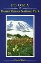 Flora
of Mount Rainier National Park, 1st Edition
Flora
of Mount Rainier National Park, 1st Edition
by David Biek.
Oregon State University Press.
Order now...
We appreciate your orders. They help keep
Go Northwest! online.
Northwest Books
from . . .
![]()
Shopping at
Go Northwest!
![]()
![]()
![]()
![]()