Back to
Puget Sound
main page
Puget Sound at a glance
ACCOMMODATIONS
Bed and Breakfast
FOOD AND BEVERAGE
Puget Sound Wineries
Seattle Wineries
VISITOR INFORMATION
Puget Sound Cities & Towns
Travel Articles
Kayaking Port Townsend and Indian Island
Kayaking Puget Sound - Best Kept Secret
Nisqually Earthquake
Seattle's Fireworks
More Washington Maps
Hood Canal
Long Beach Peninsula
Mt. Rainier Area
Mt. St. Helens Area
Olympic National Park
WA Ski Areas
Whidbey Island
More Maps
British Columbia
Idaho
Montana
Oregon
More Washington
ACTIVITIES
Sea Kayaking
Snow Skiing
Tours
Tour Operators
Whale Watching
Whitewater Rafting
FOOD AND BEVERAGE
Wine Country
VISITOR INFORMATION
List of Cities by Region
List of Cities Alphabetical
Map of Washington
Washington Travel Regions and Maps
Map
Cascade Mountains
Map
Northeast
Map
Northwest
Map
Olympic Peninsula
Map
Puget Sound
Map
San Juan Islands
Map
South Central
Map
Southeast
Map
Southwest
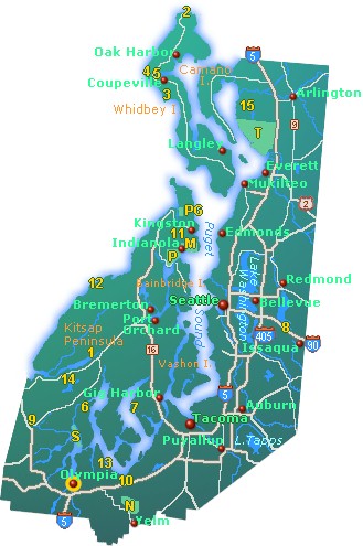
Puget Sound Map
This map of Puget Sound (part of the Salish Sea), shows the major cities and towns including Olympia, the capitol of Washington, as well as Seattle, Bellevue and Port Orchard. Locate Belfair, Deceptions Pass, Lake Sammamish, Jarrell Cove and Scenic Beach State Parks to name a few. Find tourist attractions and other points of interest including Mason County Historical Museum and the Nisqually National Wildlife Refuge. Click on a city on the map to find information on accommodations and lodging, dining, attractions and points of interest, outdoor recreation and activities.
|
 |

Go Northwest!
Bookstore
Best selection of books on the Northwest.
Click
here!
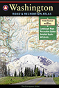 Benchmark
Washington Road & Recreation Atlas, 6th Edition by Benchmark Map.
Field-checked Landscape Maps(tm) show complete road detail. The revised
recreation guide is organized by categories such as attractions and activities.
The metro map section covers the greater Seattle-Tacoma area.
Order now...
Benchmark
Washington Road & Recreation Atlas, 6th Edition by Benchmark Map.
Field-checked Landscape Maps(tm) show complete road detail. The revised
recreation guide is organized by categories such as attractions and activities.
The metro map section covers the greater Seattle-Tacoma area.
Order now...
 Biking
Puget Sound: 60 Rides from Olympia to the San Juans, 2nd Edition by Bill Thorness.
This Mountaineers book highlights 60 of the best routes with amazing scenery along with the Handy at a Glance chart
including the routes features, difficulty level, length, elevation gain, time and points of interest.
Order now...
Biking
Puget Sound: 60 Rides from Olympia to the San Juans, 2nd Edition by Bill Thorness.
This Mountaineers book highlights 60 of the best routes with amazing scenery along with the Handy at a Glance chart
including the routes features, difficulty level, length, elevation gain, time and points of interest.
Order now...
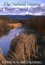 Natural History of Puget Sound Country by Arthur R. Kruckeberg.
Explore the history of the Puget Sound beginning with how ice ages and vulcanism shaped
the land. Learn about the flora, fauna, climate and special habitats
through descriptions, photos and drawings.
Order now...
Natural History of Puget Sound Country by Arthur R. Kruckeberg.
Explore the history of the Puget Sound beginning with how ice ages and vulcanism shaped
the land. Learn about the flora, fauna, climate and special habitats
through descriptions, photos and drawings.
Order now...
 A
Complete Guide To The Lighthouses on Puget Sound Including Admiralty
Inlet by Christopher Petrich. Full featured companion guide to the Puget Sound
lighthouses featuring history, locations and hours, maps, driving directions and
photographs.
Order now...
A
Complete Guide To The Lighthouses on Puget Sound Including Admiralty
Inlet by Christopher Petrich. Full featured companion guide to the Puget Sound
lighthouses featuring history, locations and hours, maps, driving directions and
photographs.
Order now...
We appreciate your orders. They help keep
Go Northwest! online.
Northwest Books
from . . .
![]()
Shopping at
Go Northwest!
![]()
![]()
![]()
![]()
Go Northwest!® gonorthwest.com (tm)
Go Northwest!®
gonorthwest.com (tm) and GoNorthwest.com (tm) are trademarks of Go
Northwest, LLC
All original text, maps, photographs, and other images on this web site, as
well as the compilation and design thereof, are
Copyright © 1997-2020 Go Northwest, LLC. All rights reserved.