![]()
![]()
![]()
![]()
Back to
Washington
main page
Cities and Towns of South Central Washington
Bingen
Goldendale
Grandview
Husum
Lyle
Naches
Sunnyside
Toppenish
Trout Lake
White Salmon
Yakima
Zillah
More Washington Maps
Hood Canal
Long Beach Peninsula
Mt. Rainier Area
Mt. St. Helens Area
Olympic National Park
WA Ski Areas
Whidbey Island
More Maps
British Columbia
Idaho
Montana
Oregon
More Washington
ACTIVITIES
Sea Kayaking
Snow Skiing
Tours
Tour Operators
Whale Watching
Whitewater Rafting
FOOD AND BEVERAGE
Wine Country
VISITOR INFORMATION
Cities and Towns
Map of Washington
Washington Travel Regions and Maps
Map
Cascade Mountains
Map
Northeast
Map
Northwest
Map
Olympic Peninsula
Map
Puget Sound
Map
San Juan Islands
Map
South Central
Map
Southeast
Map
Southwest
South Central Washington
Map
This map of the South Central region in Washington highlights major interstate and state highways, cities and towns. Find scenic wilderness areas such as Mount Adams Wilderness, Toppenish National Wildlife Refuge along with other state parks, and points of interest featuring a Stonehenge Replica at Maryhill State Park and the Columbia River Gorge. Click on any to city or town to find more information on accommodations and lodging, activities and outdoor recreation, attractions, food and beverage, visitor information and shopping venues. Utilize the left column to find more information on south central Washington and more Washington maps.
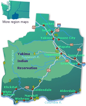
| 1 | Brooks Memorial State Park |
| 2 | Conboy Lake National Wildlife Refuge |
| 3 | Crow Butte State Park |
| 4 | Fort Simcoe State Park |
| 5 | Goldendale Observatory State Park |
| 6 | Horsethief Lake State Park |
| 7 | Indian Rock Paintings State Park |
| 8 | Maryhill State Park |
| 9 | Mount Adams Wilderness |
| 10 | Stonehenge Memorial |
| 11 | Toppenish National Wildlife Refuge |
| 12 | Yakima Nation Museum |
| 13 | Yakima Sportsman State Park |
 |
|
Go Northwest!
Bookstore
Best selection of books on the Northwest.
Click
here!
 Moon
Washington, 11th Edition (Moon Handbooks) by Matthew Lombardi. This
travel writer and Seattle resident gives an insider's view of everything
the Evergreen State has to offer such as great places to eat, scenic
drives and volunteer vacations. Discover Seattle's arts and culture,
details on climbing Mt Rainier and so much more.
Order now...
Moon
Washington, 11th Edition (Moon Handbooks) by Matthew Lombardi. This
travel writer and Seattle resident gives an insider's view of everything
the Evergreen State has to offer such as great places to eat, scenic
drives and volunteer vacations. Discover Seattle's arts and culture,
details on climbing Mt Rainier and so much more.
Order now...
 Hidden
Washington: Including Seattle, Puget Sound, San Juan Islands, Olympic
Peninsula, Cascades and Columbia River Gorge (Hidden Travel) by Eric
Lucas. This author gets to know each community by going from neighborhood to
neighborhood. This book will take you to all the great spots while
describing both the famous attractions and hidden favorites.
Order now...
Hidden
Washington: Including Seattle, Puget Sound, San Juan Islands, Olympic
Peninsula, Cascades and Columbia River Gorge (Hidden Travel) by Eric
Lucas. This author gets to know each community by going from neighborhood to
neighborhood. This book will take you to all the great spots while
describing both the famous attractions and hidden favorites.
Order now...
 Frommer's Washington State,
7th Edition by Karl Samson. This expert author tells you where to find great places to stay in every price range,
the best outdoor recreation and much more. Utilize the planning tools to
maximize your next adventure in the Evergreen State.
Order now...
Frommer's Washington State,
7th Edition by Karl Samson. This expert author tells you where to find great places to stay in every price range,
the best outdoor recreation and much more. Utilize the planning tools to
maximize your next adventure in the Evergreen State.
Order now...
 Washington Off the Beaten Path, 9th Edition (Off the Beaten Path Series)
by Chloe Ernst. This book features the unique things to see and do
from quirky cultural tidbits to hidden attractions and unique finds to
local dining. Travel off the beaten path for a one of a king experience.
Order now...
Washington Off the Beaten Path, 9th Edition (Off the Beaten Path Series)
by Chloe Ernst. This book features the unique things to see and do
from quirky cultural tidbits to hidden attractions and unique finds to
local dining. Travel off the beaten path for a one of a king experience.
Order now...
![]() Washington
Icons: 50 Classic Views of the Evergreen State by Harriet Baskas. 50
essays and more than 100 color photographs comprise this celebration of the
Evergreen State's people, places, inventions, and other iconic and unique
elements that make up the great state.
Order now...
Washington
Icons: 50 Classic Views of the Evergreen State by Harriet Baskas. 50
essays and more than 100 color photographs comprise this celebration of the
Evergreen State's people, places, inventions, and other iconic and unique
elements that make up the great state.
Order now...
 Washington
Curiosities, 3rd Edition: Quirky Characters, Roadside Oddities & Other
Offbeat Stuff by Harriet Baskas. Discover all of the unique landmarks, quirky
and offbeat
people and odd places that the Evergreen State has to offer along with local
humor and a little trivia.
Order now...
Washington
Curiosities, 3rd Edition: Quirky Characters, Roadside Oddities & Other
Offbeat Stuff by Harriet Baskas. Discover all of the unique landmarks, quirky
and offbeat
people and odd places that the Evergreen State has to offer along with local
humor and a little trivia.
Order now...
We appreciate your orders. They help keep
Go Northwest! online.
Northwest Books
from . . .
![]()
Shopping at
Go Northwest!
![]()
![]()
![]()
![]()