Back to
Washington Cascades
main page
The town and road map of Washington's Cascades will help you locate cities, towns, attractions and points of interest.
More
Cascades
North Cascades
Central Cascades
South Cascades
Cities and Towns of the Washington Cascades
Travel Articles
A Hike to Blanca Lake
A Hike to Lake Talapus
A Hike up Mount Si
Mountain Passes
Blewett Pass
Snoqualmie Pass
-Hiking
-Skiing
-Scenic Drives
Stevens Pass
-View Cam
White Pass
National Forests
Gifford Pinchot
Mt. Baker-Snoqualmie
Okanogan-Wenatchee
National Parks
Mount Rainier
Mount St. Helens
North Cascades
National Recreation Areas
Lake Chelan
Mt Baker
Ross Lake
National Wilderness Areas
Alpine Lakes
Boulder River
Clearwater
Glacier Peak
Glacier View
Goat Rocks
Henry M Jackson
Indian Heaven
Lake Chelan-Sawtooth
Mt Adams
Mt Baker
Noisy-Diobsud
Norse Peak
Pasayten
Tatoosh
Trapper Creek
William Douglas
Scenic Drives
Cascade Loop
Mt Baker Highway
North Cascades Hwy
Snoqualmie Pass
Stephen Mather Memorial Parkway
Stevens Pass
Scenic Sights
Snoqualmie Falls
Ski Areas
Crystal Mountain
Echo Valley
Loup Loup
Methow Valley
Mission Ridge
Mt. Baker
Mt Tahoma
Powder Cats
Sitzmark Lifts
Stevens Pass
Summit at Snoqualmie
Sun Mountain
White Pass
Washington Travel Regions and Maps
Map
Cascade Mountains
Map
Northeast
Map
Northwest
Map
Olympic Peninsula
Map
Puget Sound
Map
San Juan Islands
Map
South Central
Map
Southeast
Map
Southwest
Washington Cascades
Visitor Information
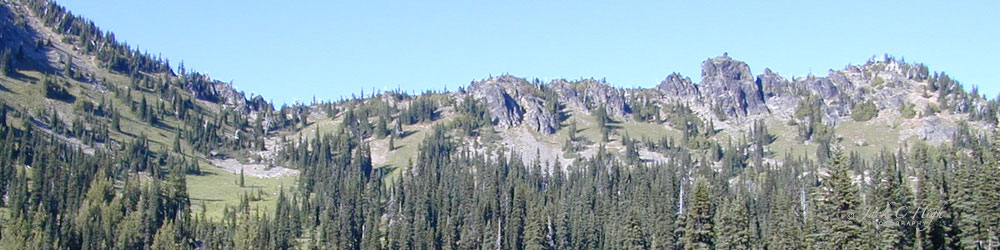
The Washington Cascades are part of the Cascade Mountain Range which extends from British Columbia to California and is dominated by several snow-capped volcanoes, two national parks, dozens of wilderness areas and millions of acres of forest.
The volcanoes in Washington are, from north to south, Mount Baker (10,775'), Glacier Peak (10,541'), Mount Rainier (14,411'), Mount Adams (12,276') and Mount St. Helens (8,366').
VISITOR INFORMATION
Washington State
Mountain Pass Report
While some mountain passes are kept open all year round (Snoqualmie,
Stevens, White), all are subject to winter snows and temporary closure due
to problems such as weather and avalanches. Chains might be required. This
web site provides seasonal reports on Washington State's mountain pass highways.
Washington Wilderness Campaign. 305 N. 83rd Street, Seattle, WA 98103. Phone: 206-633-1992.
The Washington Wilderness Campaign is a broad alliance of conservation, recreation, angling, religious and other grassroots organizations dedicated to permanently protecting roadless and wild public land across Washington State.
ACTIVITIES
Alpine
Adventure's Wild & Scenic River Tours
Offers whitewater rafting or relaxing river floats through spectacular
scenery with family, friends, and groups. Trips on any of 10 rivers in
Washington's Cascade Mountains. Washington State Licensed.
Washington Trails Association
Information and tips for Northwest hikers, including a growing list of
Trail Reviews contributed by online users, flora and fauna guides,
backcountry kitchen and more.
Go Northwest!
Bookstore
Best selection of books on the Northwest.
Click
here!
 Wildflowers
of the Western Cascades by Robert A. Ross, Henrietta L. Chambers and
Shirley A. Stevenson. A practical field guide to a rich wildflower area,
this book combines useful plant descriptions with truly spectacular
photographs. All the wildflowers are found on Oregon's Iron Mountain in the
Cascades, but the book is useful throughout the region.
Order now...
Wildflowers
of the Western Cascades by Robert A. Ross, Henrietta L. Chambers and
Shirley A. Stevenson. A practical field guide to a rich wildflower area,
this book combines useful plant descriptions with truly spectacular
photographs. All the wildflowers are found on Oregon's Iron Mountain in the
Cascades, but the book is useful throughout the region.
Order now...
 Cascades
Rock - 160 Best Multipitch Climbs of All Grades by Blake Herrington. This book is full of information including details
on routes, topos and stories of local climbers covering mountain and alpine routes in the Cascade Mountains of Washington and BC
plus rock climbing in nearby towns.
Order now...
Cascades
Rock - 160 Best Multipitch Climbs of All Grades by Blake Herrington. This book is full of information including details
on routes, topos and stories of local climbers covering mountain and alpine routes in the Cascade Mountains of Washington and BC
plus rock climbing in nearby towns.
Order now...
 Frommer's Washington State,
7th Edition by Karl Samson. This expert author tells you where to find great places to stay in every price range,
the best outdoor recreation and much more. Utilize the planning tools to
maximize your next adventure in the Evergreen State.
Order now...
Frommer's Washington State,
7th Edition by Karl Samson. This expert author tells you where to find great places to stay in every price range,
the best outdoor recreation and much more. Utilize the planning tools to
maximize your next adventure in the Evergreen State.
Order now...
 Moon
Washington, 11th Edition (Moon Handbooks) by Matthew Lombardi. This
travel writer and Seattle resident gives an insider's view of everything
the Evergreen State has to offer such as great places to eat, scenic
drives and volunteer vacations. Discover Seattle's arts and culture,
details on climbing Mt Rainier and so much more.
Order now...
Moon
Washington, 11th Edition (Moon Handbooks) by Matthew Lombardi. This
travel writer and Seattle resident gives an insider's view of everything
the Evergreen State has to offer such as great places to eat, scenic
drives and volunteer vacations. Discover Seattle's arts and culture,
details on climbing Mt Rainier and so much more.
Order now...
 Hidden Washington: Including Seattle, Puget Sound, San Juan Islands,
Olympic Peninsula, Cascades and Columbia River Gorge (Hidden Travel) by
Eric Lucas. This author gets to know each community by going from
neighborhood to neighborhood. This book will take you to all the great
spots while describing both the famous attractions and hidden favorites.
Order now...
Hidden Washington: Including Seattle, Puget Sound, San Juan Islands,
Olympic Peninsula, Cascades and Columbia River Gorge (Hidden Travel) by
Eric Lucas. This author gets to know each community by going from
neighborhood to neighborhood. This book will take you to all the great
spots while describing both the famous attractions and hidden favorites.
Order now...
 Washington Off the Beaten Path, 9th Edition (Off the Beaten Path Series)
by Chloe Ernst. This book features the unique things to see and do
from quirky cultural tidbits to hidden attractions and unique finds to
local dining. Travel off the beaten path for a one of a king experience.
Order now...
Washington Off the Beaten Path, 9th Edition (Off the Beaten Path Series)
by Chloe Ernst. This book features the unique things to see and do
from quirky cultural tidbits to hidden attractions and unique finds to
local dining. Travel off the beaten path for a one of a king experience.
Order now...
We appreciate your orders. They help keep
Go Northwest! online.
Northwest Books
from . . .
![]()
Shopping at
Go Northwest!
![]()
![]()
![]()
![]()