![]()
![]()
![]()
![]()
Back to
Southeast WA
main page
Cities and Towns of Southeast Washington
Benton City
Clarkston
Colfax
Ellensburg
Kennewick
Moses Lake
Othello
Pasco
Pomeroy
Prosser
Pullman
Richland
Ritzville
Walla Walla
More Washington Maps
Hood Canal
Long Beach Peninsula
Mt. Rainier Area
Mt. St. Helens Area
Olympic National Park
WA Ski Areas
Whidbey Island
More Maps
British Columbia
Idaho
Montana
Oregon
More Washington
ACTIVITIES
Sea Kayaking
Snow Skiing
Tours
Tour Operators
Whale Watching
Whitewater Rafting
FOOD AND BEVERAGE
Wine Country
VISITOR INFORMATION
Cities and Towns
Map of Washington
Washington Travel Regions and Maps
Map
Cascade Mountains
Map
Northeast
Map
Northwest
Map
Olympic Peninsula
Map
Puget Sound
Map
San Juan Islands
Map
South Central
Map
Southeast
Map
Southwest
Southeast Washington
Map
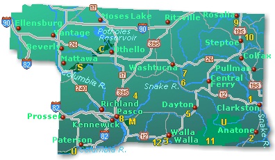
This map of the Southeast region in Washington highlights major interstate and state highways, cities and towns. Find scenic wilderness areas along the Columbia and Snake Rivers, and points of interest featuring Lewis and Clark Trail State Park, Whitman Mission National Historic Site, Steptoe Battlefield, Steptoe Butte, and Fort Walla Walla. Click on any to city or town to find more information on accommodations and lodging, activities and outdoor recreation, attractions, food and beverage, visitor information and shopping venues. Utilize the left column to find more information on southeastern Washington and more Washington maps.
|
 |
Go Northwest!
Bookstore
Best selection of books on the Northwest.
Click
here!
 Moon
Washington, 11th Edition (Moon Handbooks) by Matthew Lombardi. This
travel writer and Seattle resident gives an insider's view of everything
the Evergreen State has to offer such as great places to eat, scenic
drives and volunteer vacations. Discover Seattle's arts and culture,
details on climbing Mt Rainier and so much more.
Order now...
Moon
Washington, 11th Edition (Moon Handbooks) by Matthew Lombardi. This
travel writer and Seattle resident gives an insider's view of everything
the Evergreen State has to offer such as great places to eat, scenic
drives and volunteer vacations. Discover Seattle's arts and culture,
details on climbing Mt Rainier and so much more.
Order now...
 Weird
Washington: Your Travel Guide to Washington's Local Legends and Best Kept
Secrets. by Jefferson Davis and Al Eufrasio. An offbeat journey through
Washington's hidden history, macabre mysteries, funky folklore, and strange
sights. From Sasquatch to Stonehenge, from ghosts to Goddess Kring, it's a
trip you won't soon forget!
Order now...
Weird
Washington: Your Travel Guide to Washington's Local Legends and Best Kept
Secrets. by Jefferson Davis and Al Eufrasio. An offbeat journey through
Washington's hidden history, macabre mysteries, funky folklore, and strange
sights. From Sasquatch to Stonehenge, from ghosts to Goddess Kring, it's a
trip you won't soon forget!
Order now...
 Frommer's Washington State,
7th Edition by Karl Samson. This expert author tells you where to find great places to stay in every price range,
the best outdoor recreation and much more. Utilize the planning tools to
maximize your next adventure in the Evergreen State.
Order now...
Frommer's Washington State,
7th Edition by Karl Samson. This expert author tells you where to find great places to stay in every price range,
the best outdoor recreation and much more. Utilize the planning tools to
maximize your next adventure in the Evergreen State.
Order now...
 Great
Places: Washington: A Recreational Guide to Washington's Public Lands and
Historic Places for Birding, Hiking, Photography, Fishing, Hunting and
Camping
by John Kruse. The geology, animal and plant life, and history of
Washington's most-storied and scenic locales, including the best local
lodging and amenities are explained in this full color guide.
Order now...
Great
Places: Washington: A Recreational Guide to Washington's Public Lands and
Historic Places for Birding, Hiking, Photography, Fishing, Hunting and
Camping
by John Kruse. The geology, animal and plant life, and history of
Washington's most-storied and scenic locales, including the best local
lodging and amenities are explained in this full color guide.
Order now...
 Wild
Roads Washington: 80 Scenic Drives to Camping, Hiking Trails, and Adventures
by Seabury Blair Jr. This adventure guidebook details the forest roads of
Washington with information on hikes off each route as well as driving
routes that provide scenic vistas almost as good as those reached by foot.
Order now...
Wild
Roads Washington: 80 Scenic Drives to Camping, Hiking Trails, and Adventures
by Seabury Blair Jr. This adventure guidebook details the forest roads of
Washington with information on hikes off each route as well as driving
routes that provide scenic vistas almost as good as those reached by foot.
Order now...
 Historical
Atlas of Washington and Oregon by Derek Hayes. Illustrated with more
than 500 colorful images and maps. Provides a visually rich and textually
engaging history of the states of Oregon and Washington. A valuable
reference through history, this book presents readers with a chronicle of
how these proud states came into their own and how they each look toward the
future.
Order now...
Historical
Atlas of Washington and Oregon by Derek Hayes. Illustrated with more
than 500 colorful images and maps. Provides a visually rich and textually
engaging history of the states of Oregon and Washington. A valuable
reference through history, this book presents readers with a chronicle of
how these proud states came into their own and how they each look toward the
future.
Order now...
We appreciate your orders. They help keep
Go Northwest! online.
Northwest Books
from . . .
![]()
Shopping at
Go Northwest!
![]()
![]()
![]()
![]()