![]()
![]()
![]()
![]()
Back to
Viewpoints
main page
Viewpoints
Alki Beach Park
Beacon Hill Viewpoint
Admiral Way Viewpoint
Charles A Richey Snr. Viewpoint
Don Armeni Boat Ramp & Viewpoint
Four Columns Park
Jose Rizal Park
Harborview Park
Hamilton Viewpoint Park
Kerry Viewpoint Park
Kinnear Park
Luna Park Seawall
Seacrest Park
Space Needle
Terminal 5 Public Shoreline Access
Thomas Street Park
Victor Steinbrueck Park
Volunteer Park
More Seattle
Travel Articles
Maritime Festival
Seafair Torchlight Parade
Cities and Towns
of Puget Sound
Washington Travel Regions and Maps
Map
Cascade Mountains
Map
Northeast
Map
Northwest
Map
Olympic Peninsula
Map
Puget Sound
Map
San Juan Islands
Map
South Central
Map
Southeast
Map
Southwest
Seattle Viewpoints
Admiral Way
Location
3600 Admiral Way SW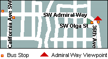
The viewpoint is on Admiral Hill in West Seattle, above Elliott Bay.
Admission
Free.
Getting there by car
Click on the map below for directions.
There is a laneway for cars going in either direction to pull in.
Getting there by bus
From downtown, via bus number 56 (Alki Beach).
Board the southbound bus at the corner of 1st Avenue and Pike
Street.
(Enjoy the view from West Seattle Bridge as you cross it on the bus.
Unfortunately no pedestrian traffic is allowed on the bridge.)
Alight from the bus at the corner of Olga Street SW and Admiral Way
SW
It is about a 15- to 25-minute ride each way, depending on whether you
catch an express bus.
On the east side of Admiral Way, you will see the "can't-miss" views of Seattle. On the west side of Admiral Way, you will see the Belvedere Park.

Notes and Tips
The viewpoint is popular, but not overrun. At most any time of day or
night you wont have to wait long for a vehicle to pull up - from coach
tours to delivery drivers stopping for a meal break. The viewpoint also
boasts a totem pole (dedicated in 1966), and small exhibit on on the
history of West Seattle, with an excerpt from the famous speech by Chief
Seattle.
The park area on the opposite side of the road does not seem to get much use as a picnic spot. Perhaps because no benches are provided, and the traffic is fairly constant.

A small local retail hub can be found by following Admiral Way a few blocks to the west where it intersects with California Avenue. In this area you will find a variety of food outlets, including two supermarkets.
No visit to West Seattle is complete without a visit to Alki Beach Park! You might find it is cheaper to grab a picnic lunch up here, or there are plenty of dining alternatives down on the beach. To get to Alki Beach, simply continue on bus route number 56 in the same direction you were originally going, and stay on until its final stop.
The Views
Admiral Way Park offers 180º views over the classic skyline of Seattle. At
this height, you can easily see the Cascade Mountains running behind the
cityscape along the horizon. To the southeast, the industrial Harbor
Island and the Port of Seattle dominate the foreground, and you can see
the West Seattle Bridge. To the northeast, you might find that foreground
foliage interrupts the blue expanse of water (Elliott Bay) that lies
between you and downtown Seattle.
Best time for photos is midday, towards the PM, and evening when the city twinkles.
Click on photo for full-size image.
|
|
|


|
|

Go Northwest!
Bookstore
Best selection of books on the Northwest.
Click here!
 Scenic
Seattle: Touring and Photographing the Emerald City by Joseph
Becker. Find descriptions, travel and historical information along
with specific advice on capturing the best shots on over 100
destinations throughout Seattle featuring viewpoints, seascapes,
landscapes and cityscapes.
Order now...
Scenic
Seattle: Touring and Photographing the Emerald City by Joseph
Becker. Find descriptions, travel and historical information along
with specific advice on capturing the best shots on over 100
destinations throughout Seattle featuring viewpoints, seascapes,
landscapes and cityscapes.
Order now...
 Moon
Seattle (Moon Handbooks) by Allison Williams. Written by a Seattleite,
this guide offers everything you need to know about the Emerald City.
Discover unique landmarks, points of interest, quirky curiosities and
hidden secrets through photos, maps and provocative descriptions to make
the most of your trip to Seattle.
Order now...
Moon
Seattle (Moon Handbooks) by Allison Williams. Written by a Seattleite,
this guide offers everything you need to know about the Emerald City.
Discover unique landmarks, points of interest, quirky curiosities and
hidden secrets through photos, maps and provocative descriptions to make
the most of your trip to Seattle.
Order now...
 Frommer's
Seattle, 10th Edition (Frommer's Color Complete) by Karl Samson. Updated information
in this user friendly guide enables you to find everything from what to
do and see to daytrips and weekend excursions to the gorgeous national
parks, Puget Sound islands, and the nearby wine country. Full color map is also included.
Order now...
Frommer's
Seattle, 10th Edition (Frommer's Color Complete) by Karl Samson. Updated information
in this user friendly guide enables you to find everything from what to
do and see to daytrips and weekend excursions to the gorgeous national
parks, Puget Sound islands, and the nearby wine country. Full color map is also included.
Order now...
 Seattle Curiosities:
Quirky characters, roadside oddities & other offbeat stuff by
Steve Pomper. This book will have you laughing out loud as you are introduced to the city's weirdest and
most outrageous characters and events, taking you places you never could have imagined.
Order now...
Seattle Curiosities:
Quirky characters, roadside oddities & other offbeat stuff by
Steve Pomper. This book will have you laughing out loud as you are introduced to the city's weirdest and
most outrageous characters and events, taking you places you never could have imagined.
Order now...
 Seattle
(City Guide), 6th Edition, by Heidi Johansen. Full color photos and maps
along with descriptions and travel advice for the best sights and
experiences make up this travel guide. Discover history, culture and the
diverse neighborhoods of Seattle.
Order now...
Seattle
(City Guide), 6th Edition, by Heidi Johansen. Full color photos and maps
along with descriptions and travel advice for the best sights and
experiences make up this travel guide. Discover history, culture and the
diverse neighborhoods of Seattle.
Order now...
 Frommer's Washington State,
7th Edition by Karl Samson. This expert author tells you where to find great places to stay in every price range,
the best outdoor recreation and much more. Utilize the planning tools to
maximize your next adventure in the Evergreen State.
Order now...
Frommer's Washington State,
7th Edition by Karl Samson. This expert author tells you where to find great places to stay in every price range,
the best outdoor recreation and much more. Utilize the planning tools to
maximize your next adventure in the Evergreen State.
Order now...
We appreciate your orders. They help keep
Go Northwest! online.
Northwest Books
from . . .
![]()
Shopping at
Go Northwest!
![]()
![]()
![]()
![]()
Go Northwest!® gonorthwest.com (tm)
Go Northwest!®
gonorthwest.com (tm) and GoNorthwest.com (tm) are trademarks of Go
Northwest, LLC
All original text, maps, photographs, and other images on this web site, as
well as the compilation and design thereof, are
Copyright © 1997-2019
Go Northwest, LLC. All rights reserved.