![]()
![]()
![]()
![]()
Back to
Northeast WA
main page
Cities and Towns of Northeast Washington
Airway Heights
Bridgeport
Cheney
Chewelah
Coulee Dam
Coulee City
Ephrata
Kettle Falls
Liberty Lake
Orient
Soap Lake
Spokane
Spokane Valley
Tonasket
Usk
Points of Interest in Northeast Washington
Dry Falls
Grand Coulee Dam
More Washington Maps
Hood Canal
Long Beach Peninsula
Mt. Rainier Area
Mt. St. Helens Area
Olympic National Park
WA Ski Areas
Whidbey Island
More Maps
British Columbia
Idaho
Montana
Oregon
Washington Travel Regions and Maps
Map
Cascade Mountains
Map
Northeast
Map
Northwest
Map
Olympic Peninsula
Map
Puget Sound
Map
San Juan Islands
Map
South Central
Map
Southeast
Map
Southwest
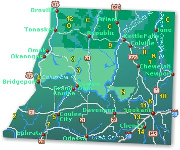
Northeast Washington
Map
This map of the Northeast region in Washington highlights major interstate and state highways, cities and towns. Find scenic wilderness areas such as the Okanogan and Colville National Forests, ski areas including Mount Spokane, 49° North, and Badger Mountain, along with points of interest featuring Dry Falls, the largest waterfall known to have existed on earth, Grand Coulee Dam, one of the largest concrete structures in the world, Chief Joseph Memorial, Lake Lenore Caves and Turnbull National Wildlife Refuge located in Cheney. Click on any to city or town to find more information on accommodations and lodging, activities and outdoor recreation, attractions, food and beverage, visitor information and shopping venues. Utilize the left column to find more information on northeastern Washington and more Washington maps.
|
 |
Go Northwest!
Bookstore
Best selection of books on the Northwest.
Click here!
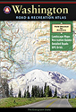 Benchmark
Washington Road & Recreation Atlas, 6th Edition by Benchmark Map.
Field-checked Landscape Maps(tm) show complete road detail. The revised
recreation guide is organized by categories such as attractions and activities.
The metro map section covers the greater Seattle-Tacoma area.
Order now...
Benchmark
Washington Road & Recreation Atlas, 6th Edition by Benchmark Map.
Field-checked Landscape Maps(tm) show complete road detail. The revised
recreation guide is organized by categories such as attractions and activities.
The metro map section covers the greater Seattle-Tacoma area.
Order now...
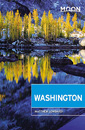 Moon
Washington, 11th Edition (Moon Handbooks) by Matthew Lombardi. This
travel writer and Seattle resident gives an insider's view of everything
the Evergreen State has to offer such as great places to eat, scenic
drives and volunteer vacations. Discover Seattle's arts and culture,
details on climbing Mt Rainier and so much more.
Order now...
Moon
Washington, 11th Edition (Moon Handbooks) by Matthew Lombardi. This
travel writer and Seattle resident gives an insider's view of everything
the Evergreen State has to offer such as great places to eat, scenic
drives and volunteer vacations. Discover Seattle's arts and culture,
details on climbing Mt Rainier and so much more.
Order now...
 Wild
Roads Washington: 80 Scenic Drives to Camping, Hiking Trails, and Adventures
by Seabury Blair Jr. This adventure guidebook details the forest roads of
Washington with information on hikes off each route as well as driving
routes that provide scenic vistas almost as good as those reached by foot.
Order now...
Wild
Roads Washington: 80 Scenic Drives to Camping, Hiking Trails, and Adventures
by Seabury Blair Jr. This adventure guidebook details the forest roads of
Washington with information on hikes off each route as well as driving
routes that provide scenic vistas almost as good as those reached by foot.
Order now...
 Weird
Washington: Your Travel Guide to Washington's Local Legends and Best Kept
Secrets. by Jefferson Davis and Al Eufrasio. An offbeat journey through
Washington's hidden history, macabre mysteries, funky folklore, and strange
sights. From Sasquatch to Stonehenge, from ghosts to Goddess Kring, it's a
trip you won't soon forget!
Order now...
Weird
Washington: Your Travel Guide to Washington's Local Legends and Best Kept
Secrets. by Jefferson Davis and Al Eufrasio. An offbeat journey through
Washington's hidden history, macabre mysteries, funky folklore, and strange
sights. From Sasquatch to Stonehenge, from ghosts to Goddess Kring, it's a
trip you won't soon forget!
Order now...
 Frommer's Washington State,
7th Edition by Karl Samson. This expert author tells you where to find great places to stay in every price range,
the best outdoor recreation and much more. Utilize the planning tools to
maximize your next adventure in the Evergreen State.
Order now...
Frommer's Washington State,
7th Edition by Karl Samson. This expert author tells you where to find great places to stay in every price range,
the best outdoor recreation and much more. Utilize the planning tools to
maximize your next adventure in the Evergreen State.
Order now...
We appreciate your orders. They help keep
Go Northwest! online.
Northwest Books
from . . .
![]()
Shopping at
Go Northwest!
![]()
![]()
![]()
![]()