![]()
![]()
![]()
![]()
Back to
Northeast Oregon
main page
Cities and Towns of Northeast Oregon
Baker City
Enterprise
Halfway
Hermiston
John Day
Joseph
Kimberly
La Grande
Lostine
North Powder
Oxbow
Pendleton
Wallowa
More Oregon
ACTIVITIES
Snow Skiing
Tours
Tour Operators
Whitewater Rafting
ATTRACTIONS
Lighthouses
-Haceta Head
FOOD AND BEVERAGE
Wine Country
VISITOR INFORMATION
List of Cities and Towns
Map of Oregon
Oregon Travel Regions and Maps:
Map
Cascade Mountains
Map
Central
Map
Coast
Map
Columbia River
Map
Northeast
Map
Portland Area
Map
Southern
Map
Willamette Valley
Northeast Oregon
Map
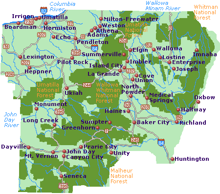
This map of Northeast Oregon shows the major interstates and state highways, cities and towns. Find scenic wilderness areas in one of the four National Forests (Whitman, Umatilla, Wallowa or Malheur), or along the Columbia, John Day or Wallowa Minam Rivers, and points of interest featuring the Oregon Trail Interpretive Center, located 5 miles east of Baker City on Highway 86, and Tamastslikt Cultural Institute, located on the grounds of the Wildhorse Resort & Casino, 10 minutes east of Pendleton. Click on any to city or town to find more information on accommodations and lodging, activities and outdoor recreation, attractions, food and beverage, visitor information and shopping venues. Utilize the left column to find more information on Northeast Oregon and more Oregon maps.
Go Northwest!
Bookstore
Best selection of books on the Northwest.
Click here!
 Moon
Oregon, 11th Edition by Judy Jewell and W. C. McRae.
Find all the information you need including to plan a memorable trip to Oregon with the insights
from the authors who reside in Portland. Discover the best recreational
activities, coolest sights to see and much more in this full color guidebook.
Order now...
Moon
Oregon, 11th Edition by Judy Jewell and W. C. McRae.
Find all the information you need including to plan a memorable trip to Oregon with the insights
from the authors who reside in Portland. Discover the best recreational
activities, coolest sights to see and much more in this full color guidebook.
Order now...
 Fodor's
Oregon, 6th Edition (Full-Color Travel Guide) by Fodor's. Discover
beautiful scenery, the newest urban towns, wine and brew venues and much
more. This guide offers advice and recommendations from the local writers,
maps, photos and descriptions of each area.
Order now...
Fodor's
Oregon, 6th Edition (Full-Color Travel Guide) by Fodor's. Discover
beautiful scenery, the newest urban towns, wine and brew venues and much
more. This guide offers advice and recommendations from the local writers,
maps, photos and descriptions of each area.
Order now...
 Oregon:
An Explorer's Guide, 3rd Edition by Denise Fainberg. New color highlights
make it easier to find the info you need. Includes: getting there, getting
around, what to see, what to do, green space, family activities, where to
stay and eat, entertainment, selective shopping, special events, and more.
Color highlights throughout, 100 black-and-white photographs.
Order now...
Oregon:
An Explorer's Guide, 3rd Edition by Denise Fainberg. New color highlights
make it easier to find the info you need. Includes: getting there, getting
around, what to see, what to do, green space, family activities, where to
stay and eat, entertainment, selective shopping, special events, and more.
Color highlights throughout, 100 black-and-white photographs.
Order now...
 Backroads
& Byways of Oregon: Drives, Day Trips & Weekend Excursions by Crystal
Wood. With natives as your guides, this series leads you down the road less
traveled. Offering up 11 distinctive road trips and weekend getaways-from
the awe-inspiring Oregon Coast to the geological wonders of Mt. Hood-this
one-of-a-kind guide reveals the quirks and little-known delights of the
"real" Oregon.
Order now...
Backroads
& Byways of Oregon: Drives, Day Trips & Weekend Excursions by Crystal
Wood. With natives as your guides, this series leads you down the road less
traveled. Offering up 11 distinctive road trips and weekend getaways-from
the awe-inspiring Oregon Coast to the geological wonders of Mt. Hood-this
one-of-a-kind guide reveals the quirks and little-known delights of the
"real" Oregon.
Order now...
We appreciate your orders. They help keep
Go Northwest! online.
Northwest Books
from . . .
![]()
Shopping at
Go Northwest!
![]()
![]()
![]()
![]()