![]()
![]()
![]()
Where to stay and
what to do in
Ephrata
More Northeast Washington
Airway Heights
Bridgeport
Cheney
Chewelah
Colville
Coulee City
Coulee Dam
Ephrata
Kettle Falls
Liberty Lake
Newport
Omak
Soap Lake
Spokane
Spokane Valley
Tonasket
Washington Travel Regions and Maps
Map
Cascade Mountains
Map
Northeast
Map
Northwest
Map
Olympic Peninsula
Map
Puget Sound
Map
San Juan Islands
Map
South Central
Map
Southeast
Map
Southwest
Ephrata, Washington
Ephrata (ee-FRAY-ta) is a tidy town of slightly over 8,000 set amidst a sprinkling of trees and surrounded by miles of flat and desolate desert-scape with short grasses and sage, with short grasses and sage, alternating with irrigated fields of verdant crops. The town stretches for over a mile along Basin St. and is headquarters to the Columbia Basin Reclamation Project, the irrigation arm of the Grand Coulee Dam project. Few towns in Washington were more desolate than Ephrata before the irrigation project arrived in the 1950s. The name comes from the Biblical village where Christ was born, Bethlehem Ephratah, and supposedly originated when a traveler on the Great Northern Railway stopped here and found a prospering orchard irrigated by a spring. It reminded him of the Holy Land, and the name stuck. (Ephratah means fertile region.)
The information above is reproduced with permission of Avalon Publishing Group, © 2002, Moon Handbooks: Washington by Don Pitcher.
|
Weather
|
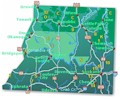
The town and road map of Northeast Washington will help you locate cities, towns, attractions and points of interest. |

Go Northwest!
Bookstore
Best selection of books on the Northwest.
Click here!
 Moon
Washington, 11th Edition (Moon Handbooks) by Matthew Lombardi. This
travel writer and Seattle resident gives an insider's view of everything
the Evergreen State has to offer such as great places to eat, scenic
drives and volunteer vacations. Discover Seattle's arts and culture,
details on climbing Mt Rainier and so much more.
Order now...
Moon
Washington, 11th Edition (Moon Handbooks) by Matthew Lombardi. This
travel writer and Seattle resident gives an insider's view of everything
the Evergreen State has to offer such as great places to eat, scenic
drives and volunteer vacations. Discover Seattle's arts and culture,
details on climbing Mt Rainier and so much more.
Order now...
 Washington Off the Beaten Path, 9th Edition (Off the Beaten Path Series)
by Chloe Ernst. This book features the unique things to see and do
from quirky cultural tidbits to hidden attractions and unique finds to
local dining. Travel off the beaten path for a one of a king experience.
Order now...
Washington Off the Beaten Path, 9th Edition (Off the Beaten Path Series)
by Chloe Ernst. This book features the unique things to see and do
from quirky cultural tidbits to hidden attractions and unique finds to
local dining. Travel off the beaten path for a one of a king experience.
Order now...
 Explorer's
Guide Washington, 2nd Edition (Explorer's Complete) by Denise Fainberg.
This local author highlights the diverse landscapes of Washington from
eastern deserts to the rainforest in the west side of the state. Explore
iconic sites such as Mt. St. Helens, Mt. Rainier and Grand Coulee Dam
and many other beautiful places.
Order now...
Explorer's
Guide Washington, 2nd Edition (Explorer's Complete) by Denise Fainberg.
This local author highlights the diverse landscapes of Washington from
eastern deserts to the rainforest in the west side of the state. Explore
iconic sites such as Mt. St. Helens, Mt. Rainier and Grand Coulee Dam
and many other beautiful places.
Order now...
We appreciate your orders. They help keep
Go Northwest! online.
Northwest Books
from . . .
![]()
Shopping at
Go Northwest!
![]()
![]()
![]()
![]()