![]()
![]()
![]()
![]()
Back to
Langley
main page
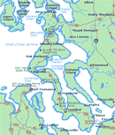
The Whidbey Island Map will help you locate cities, towns and highways.
ACCOMMODATIONS
Bed Breakfast
Cabins and Cottages
Campgrounds/RV Parks
Hotels and Motels
Vacation Rentals
More Langley

Nearby Cities and Towns
Clinton, 6 miles
Coupeville, 27 miles
Freeland, 9 miles
Greenbank, 15 miles
Oak Harbor, 37 miles
Whidbey Island, 18 miles
Washington State Ferry Service
Schedules
Route Map
Weather
Washington Travel Regions and Maps
Map
Cascade Mountains
Map
Northeast
Map
Northwest
Map
Olympic Peninsula
Map
Puget Sound
Map
San Juan Islands
Map
South Central
Map
Southeast
Map
Southwest
Langley, Washington
Accommodations & Lodging
Langley has a variety of accommodations from hotels and motels with all the amenities, to intimate bed and breakfast inns, to vacation rentals that offer more privacy. Many of the accommodations are conveniently located near restaurants, shopping and recreational areas. Camping is available at both private campgrounds as well as Deception Pass and Fort Ebey State Parks. Find where to stay by choosing from the links below to find the specific type of lodging that best suites your needs.
Go Northwest!
Bookstore
Best selection of books on the Northwest.
Click here!
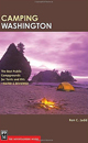
 Camping
Washington: A Comprehensive Guide to Public Tent and RV
Campgrounds, 3rd Edition (State Camping Series) by Steve Giordano and Lynn Rosen. Over 400 public
campgrounds are listed by geographic area, with necessary information
including GPS coordinates, fees and recreational activities. Site maps are
included plus tips on wildlife and safety.
Order now...
Camping
Washington: A Comprehensive Guide to Public Tent and RV
Campgrounds, 3rd Edition (State Camping Series) by Steve Giordano and Lynn Rosen. Over 400 public
campgrounds are listed by geographic area, with necessary information
including GPS coordinates, fees and recreational activities. Site maps are
included plus tips on wildlife and safety.
Order now...
 Camping
Washington: The Best Public Campgrounds for Tents and RVs--Rated and
Reviewed by Ron C. Judd. This guide outlines Washington's public campgrounds
featuring a campsite rating systems, icons for tents and RV's,
quick-reference maps, driving directions, the best hookups and showers along
with reservation information.
Order now...
Camping
Washington: The Best Public Campgrounds for Tents and RVs--Rated and
Reviewed by Ron C. Judd. This guide outlines Washington's public campgrounds
featuring a campsite rating systems, icons for tents and RV's,
quick-reference maps, driving directions, the best hookups and showers along
with reservation information.
Order now...
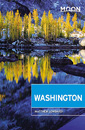 Moon
Washington, 11th Edition (Moon Handbooks) by Matthew Lombardi. This
travel writer and Seattle resident gives an insider's view of everything
the Evergreen State has to offer such as great places to eat, scenic
drives and volunteer vacations. Discover Seattle's arts and culture,
details on climbing Mt Rainier and so much more.
Order now...
Moon
Washington, 11th Edition (Moon Handbooks) by Matthew Lombardi. This
travel writer and Seattle resident gives an insider's view of everything
the Evergreen State has to offer such as great places to eat, scenic
drives and volunteer vacations. Discover Seattle's arts and culture,
details on climbing Mt Rainier and so much more.
Order now...
 Frommer's Washington State,
7th Edition by Karl Samson. This expert author tells you where to find great places to stay in every price range,
the best outdoor recreation and much more. Utilize the planning tools to
maximize your next adventure in the Evergreen State.
Order now...
Frommer's Washington State,
7th Edition by Karl Samson. This expert author tells you where to find great places to stay in every price range,
the best outdoor recreation and much more. Utilize the planning tools to
maximize your next adventure in the Evergreen State.
Order now...
 Wild
Roads Washington: 80 Scenic Drives to Camping, Hiking Trails, and Adventures
by Seabury Blair Jr. This adventure guidebook details the forest roads of
Washington with information on hikes off each route as well as driving
routes that provide scenic vistas almost as good as those reached by foot.
Order now...
Wild
Roads Washington: 80 Scenic Drives to Camping, Hiking Trails, and Adventures
by Seabury Blair Jr. This adventure guidebook details the forest roads of
Washington with information on hikes off each route as well as driving
routes that provide scenic vistas almost as good as those reached by foot.
Order now...
We appreciate your orders. They help keep
Go Northwest! online.
Northwest Books
from . . .
![]()
Shopping at
Go Northwest!
![]()
![]()
![]()
![]()