![]()
![]()
![]()
![]()
Where to stay and
what to do in
Columbia Falls
Nearby Cities and Towns
Bigfork, 26 miles
Coram, 10 miles
Hungry Horse, 7 miles
Kalispell, 16 miles
Lakeside, 30 miles
Somers, 30 miles
West Glacier, 17 miles
Whitefish, 9 miles
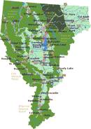
Cities and Towns of Flathead Valley
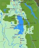
Click on Flathead Valley Area Map to locate cities and towns and other features of the Flathead Valley in Northwest Montana.
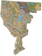
The relief map of Northwest Montana will help you locate geographical features such as rivers and mountains.
More Northwest Montana
Bitterroot
Valley
Blackfeet Indian Res.
Clark Fork River
Flathead Valley
Kootenai Valley
Missoula Valley
Seeley Swan Valley
Montana Travel Regions and Maps:
Map
North Central
Map
Northeast
Map
Northwest
Map
South Central
Map
Southeast
Map
Southwest
Northwest Montana Travel Region
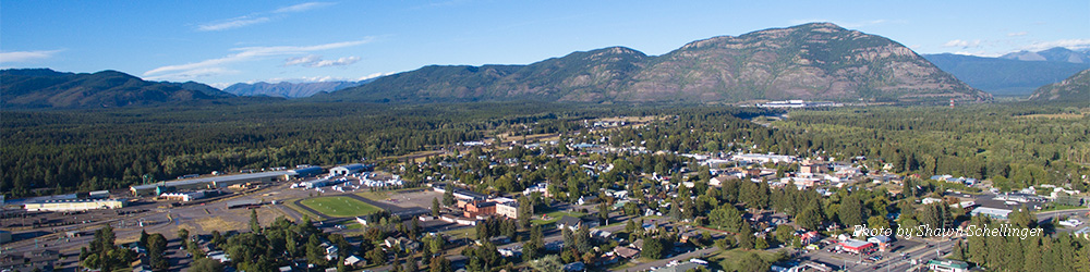
Columbia Falls, MT
Columbia Falls, Montana, best known as the southwestern gateway to Glacier National Park, sits at an elevation of 3,092 feet. Located in the heart of the Rocky Mountains, on the western edge of the Continental Divide, the city is a recreationist's paradise. Travelers come here to ski, snowboard and snowmobile, although the area is also well known for its golfing, llama-guided hikes and freshwater recreation.
 View of the Swan Range just a few miles south of Columbia Falls along
State Route 35 near the junction with Highway 82 to Kalispell.
Go Northwest! photo by Jack
High. GPS: N 48,13.6168; W 114,9.8914.
View of the Swan Range just a few miles south of Columbia Falls along
State Route 35 near the junction with Highway 82 to Kalispell.
Go Northwest! photo by Jack
High. GPS: N 48,13.6168; W 114,9.8914.
Situated near the three forks of the Flathead rivers, the city affords excellent access to fly fishing and river rafting. The more remote areas of the Middle and South Fork rivers are known for their cutthroat trout, which generally range between 8 and 12 inches in length. Bull trout have been protected since the 1950s and are catch-and-release only. Trails can be steep and some fishermen fly in to reach the best spots.
River rafting includes float-rafting on class I and II stretches and up to class VI in selected areas. The Middle Fork, which skirts the southwestern border of Glacier National Park is popular for float trips. Outfitters can be found in Columbia Falls and the nearby town of West Glacier.
But enjoyment in the Columbia Falls area isn't limited to outdoor recreation. Locally based attractions and activities include amusement parks, art and pottery galleries, antique stores and other city entertainment. Accommodation choices span from cabins and cottages, resorts and vacation rentals, to hotels, motels and bed and breakfast inns. Camping and RV parks can be found both in town and throughout the nearby national and state parks.
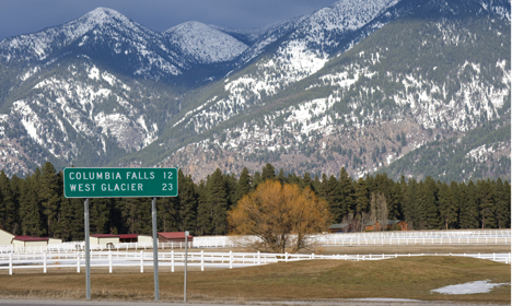
Columbia Falls lies less than a half-hour's drive east of Kalispell and approximately two hours south of the Canada-U.S. border, at the junction of Highway 2 and Highway 40.
Find all of the visitor information you need to when plan a trip to Columbia Falls. Just use the navigation links in the left hand column or the drop down menu at the top of the page to find accommodations and lodging, restaurants and dining, activities and recreation, along with attractions and points of interest.
|
Weather
|
Click on the town and road map to locate cities, towns and attractions. |

Go Northwest!
Bookstore
Best selection of books on the Northwest.
Click
here!
 Benchmark
Montana Road & Recreation Atlas by Benchmark Maps. Large-scale Landscape
MapsTM and a complete 30-page Recreation Guide make it the ideal planning
tool for any outdoor adventure. Benchmark field-checkers drove thousands of
miles to make sure the Montana Road & Recreation Atlas is the most accurate
and reliable map product.
Order now...
Benchmark
Montana Road & Recreation Atlas by Benchmark Maps. Large-scale Landscape
MapsTM and a complete 30-page Recreation Guide make it the ideal planning
tool for any outdoor adventure. Benchmark field-checkers drove thousands of
miles to make sure the Montana Road & Recreation Atlas is the most accurate
and reliable map product.
Order now...
 Moon Montana,
9th Edition (Moon Handbooks) by Judy Jewell and W.C. McRae. This guide
has complete information about all of Big Sky Country, from Yellowstone
National Park to the eastern prairies of the state, to help the traveler
plan a memorable vacation.
Order now...
Moon Montana,
9th Edition (Moon Handbooks) by Judy Jewell and W.C. McRae. This guide
has complete information about all of Big Sky Country, from Yellowstone
National Park to the eastern prairies of the state, to help the traveler
plan a memorable vacation.
Order now...
 Montana
Off the Beaten Path, 9th Edition: A Guide to Unique Places by Ednor
Therriault and Michael McCoy. Discover hidden attractions, unusual
locales, unique finds and quirky cultural tidbits; all the interesting
stuff you'd want to see and experience if you only knew about them.
Order now...
Montana
Off the Beaten Path, 9th Edition: A Guide to Unique Places by Ednor
Therriault and Michael McCoy. Discover hidden attractions, unusual
locales, unique finds and quirky cultural tidbits; all the interesting
stuff you'd want to see and experience if you only knew about them.
Order now...
 Moon
Glacier National Park, 6th Edition (Moon Handbooks) by Becky Lomax. Get
an insider's perspective on hiking the park's trails, unique trip strategies, a wildlife watching tour, a one
day Glacier tour, biking up Going-to-the-Sun Road and wildlife viewing.
Photographs and maps are included in this guide.
Order now...
Moon
Glacier National Park, 6th Edition (Moon Handbooks) by Becky Lomax. Get
an insider's perspective on hiking the park's trails, unique trip strategies, a wildlife watching tour, a one
day Glacier tour, biking up Going-to-the-Sun Road and wildlife viewing.
Photographs and maps are included in this guide.
Order now...
We appreciate your orders. They help keep
Go Northwest! online.
Northwest Books
from . . .
![]()
Shopping at
Go Northwest!
![]()
![]()
![]()
![]()