![]()
![]()
![]()
![]()
Back to
Southeast MT
main page
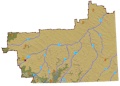
The relief map of Southeast Montana will help you locate geographical features such as rivers and mountains.
Cities and Towns of Southeast Montana
Billings
Glendive
Laurel
Miles City
More Montana
ACTIVITIES
Snow Skiing
Tours
Tour Operators
Whitewater Rafting
VISITOR INFORMATION
Cities and Towns
Map of Montana
More Maps
British Columbia
Idaho
Montana
Oregon
Washington
Montana Travel Regions and Maps:
Map
North Central
Map
Northeast
Map
Northwest
Map
South Central
Map
Southeast
Map
Southwest
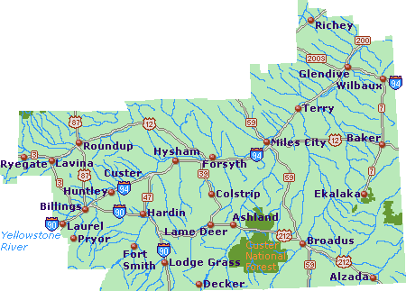
Southeast Montana: Custer Country
Map
This map of Southeast Montana, Custer Country, highlights major interstates and state highways, cities and towns. Find scenic wilderness areas including Custer National Park. Click on any to city or town to find more information on accommodations and lodging, activities and outdoor recreation, attractions, food and beverage, visitor information and shopping venues. Utilize the left column to find more information on Southeast Montana and more Montana maps.
Go Northwest!
Bookstore
Best selection of books on the Northwest.
Click
here!
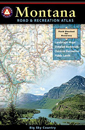 Benchmark
Montana Road & Recreation Atlas by Benchmark Maps. Large-scale Landscape
MapsTM and a complete 30-page Recreation Guide make it the ideal planning
tool for any outdoor adventure. Benchmark field-checkers drove thousands of
miles to make sure the Montana Road & Recreation Atlas is the most accurate
and reliable map product.
Order now...
Benchmark
Montana Road & Recreation Atlas by Benchmark Maps. Large-scale Landscape
MapsTM and a complete 30-page Recreation Guide make it the ideal planning
tool for any outdoor adventure. Benchmark field-checkers drove thousands of
miles to make sure the Montana Road & Recreation Atlas is the most accurate
and reliable map product.
Order now...
 Montana
River Maps & Fishing Guide by Ray Rychnovsky, Author/Editor and Esther
Poleo, Illustrator. Features the best 30 Montana rivers. Included for each
river are the best seasons, species, available illustrated fishing methods
(both fly and gear), best flies and best gear for individual rivers and
species and more.
Order now...
Montana
River Maps & Fishing Guide by Ray Rychnovsky, Author/Editor and Esther
Poleo, Illustrator. Features the best 30 Montana rivers. Included for each
river are the best seasons, species, available illustrated fishing methods
(both fly and gear), best flies and best gear for individual rivers and
species and more.
Order now...
 Moon Montana,
9th Edition (Moon Handbooks) by Judy Jewell and W.C. McRae. This guide
has complete information about all of Big Sky Country, from Yellowstone
National Park to the eastern prairies of the state, to help the traveler
plan a memorable vacation.
Order now...
Moon Montana,
9th Edition (Moon Handbooks) by Judy Jewell and W.C. McRae. This guide
has complete information about all of Big Sky Country, from Yellowstone
National Park to the eastern prairies of the state, to help the traveler
plan a memorable vacation.
Order now...
 Montana
Off the Beaten Path, 9th Edition: A Guide to Unique Places by Ednor
Therriault and Michael McCoy. Discover the hidden attractions, unusual
locales, unique finds and quirky cultural tidbits; all the interesting
stuff you'd want to see and experience if you only knew about them.
Order now...
Montana
Off the Beaten Path, 9th Edition: A Guide to Unique Places by Ednor
Therriault and Michael McCoy. Discover the hidden attractions, unusual
locales, unique finds and quirky cultural tidbits; all the interesting
stuff you'd want to see and experience if you only knew about them.
Order now...
We appreciate your orders. They help keep
Go Northwest! online.
Northwest Books
from . . .
![]()
Shopping at
Go Northwest!
![]()
![]()
![]()
![]()