![]()
![]()
![]()
![]()
Back to
South
Central MT
main page
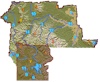
The relief map of South Central Montana will help you locate geographical features such as rivers and mountains.
Cities and Towns of South Central Montana
Absarokee
Belgrade
Big Sky
Big Timber
Bozeman
Bridger
Columbus
Cooke City
Emigrant
Gallatin Gateway
Gardiner
Livingston
Norris
Pray
Red Lodge
West Yellowstone
More Montana
ACTIVITIES
Snow Skiing
Tours
Tour Operators
Whitewater Rafting
VISITOR INFORMATION
Cities and Towns
Map of Montana
Montana Travel Regions and Maps:
Map
North Central
Map
Northeast
Map
Northwest
Map
South Central
Map
Southeast
Map
Southwest
More Maps
British Columbia
Idaho
Montana
Oregon
Washington
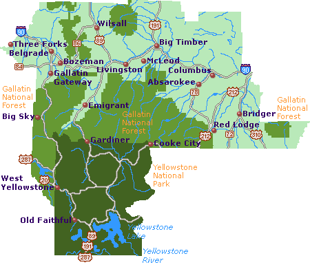
South Central Montana: Yellowstone Country
Map
This map of South Central Montana, Yellowstone Country, highlights major interstates and interstates and highways, cities and towns. Find scenic wilderness areas including Gallatin National Forest, and points of interest such as Old Faithful inside Yellowstone National Park and the scenic Beartooth Highway. Click on any to city or town to find more information on accommodations and lodging, activities and outdoor recreation, attractions, food and beverage, visitor information and shopping venues. Utilize the left column to find more information on South Central Montana and more Montana maps.
Go Northwest!
Bookstore
Best selection of books on the Northwest.
Click
here!
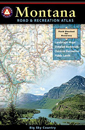 Benchmark
Montana Road & Recreation Atlas by Benchmark Maps. Large-scale Landscape
MapsTM and a complete 30-page Recreation Guide make it the ideal planning
tool for any outdoor adventure. Benchmark field-checkers drove thousands of
miles to make sure the Montana Road & Recreation Atlas is the most accurate
and reliable map product.
Order now...
Benchmark
Montana Road & Recreation Atlas by Benchmark Maps. Large-scale Landscape
MapsTM and a complete 30-page Recreation Guide make it the ideal planning
tool for any outdoor adventure. Benchmark field-checkers drove thousands of
miles to make sure the Montana Road & Recreation Atlas is the most accurate
and reliable map product.
Order now...
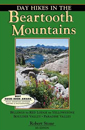 Day
Hikes In the Beartooth Mountains, 5th Edition by Robert Stone. This
edition includes an extensive collection of hikes in the Beartooth Mountain
Range bordering Yellowstone. All hikes can be done in one day and lie within
a 1200 mile radius of Red Lodge. Map sources and references are listed.
Order now...
Day
Hikes In the Beartooth Mountains, 5th Edition by Robert Stone. This
edition includes an extensive collection of hikes in the Beartooth Mountain
Range bordering Yellowstone. All hikes can be done in one day and lie within
a 1200 mile radius of Red Lodge. Map sources and references are listed.
Order now...
 Fishing
the Beartooths, 2nd Edition: An Angler's Guide to More than 400 Prime
Fishing Spots (Regional Fishing Series) by Patrick E. Marcuson.
Everything needed to plan your next fishing trip in the Absaroka and
Beartooth Mountains is in this guide including information on the fishing
destinations, location coordinates, elevation and depth of each lake.
Order now...
Fishing
the Beartooths, 2nd Edition: An Angler's Guide to More than 400 Prime
Fishing Spots (Regional Fishing Series) by Patrick E. Marcuson.
Everything needed to plan your next fishing trip in the Absaroka and
Beartooth Mountains is in this guide including information on the fishing
destinations, location coordinates, elevation and depth of each lake.
Order now...
 Montana
River Maps & Fishing Guide by Ray Rychnovsky, Author/Editor and Esther
Poleo, Illustrator. Features the best 30 Montana rivers. Included for each
river are the best seasons, species, available illustrated fishing methods
(both fly and gear), best flies and best gear for individual rivers and
species and more.
Order now...
Montana
River Maps & Fishing Guide by Ray Rychnovsky, Author/Editor and Esther
Poleo, Illustrator. Features the best 30 Montana rivers. Included for each
river are the best seasons, species, available illustrated fishing methods
(both fly and gear), best flies and best gear for individual rivers and
species and more.
Order now...
 Moon
Spotlight Yellowstone National Park by Don Pitcher. 80-page compact guide
covering must-see attractions and maps with sightseeing highlights. This
lightweight guide is packed with recommendations on sights, entertainment,
shopping, recreations, accommodations, food, and transportation, as well
as easy-to-read maps.
Order now...
Moon
Spotlight Yellowstone National Park by Don Pitcher. 80-page compact guide
covering must-see attractions and maps with sightseeing highlights. This
lightweight guide is packed with recommendations on sights, entertainment,
shopping, recreations, accommodations, food, and transportation, as well
as easy-to-read maps.
Order now...
 Montana's Historical Highway Markers by Jon Axline and Glenda Clay
Bradshaw. Discover Montana's history by the roadside markers and signs.
This book has historic photos and easy to follow maps to the signs
locations. Learn the stories of the people of Montana.
Order now...
Montana's Historical Highway Markers by Jon Axline and Glenda Clay
Bradshaw. Discover Montana's history by the roadside markers and signs.
This book has historic photos and easy to follow maps to the signs
locations. Learn the stories of the people of Montana.
Order now...
 Montana
Adventure Guide by Genevieve Rowles. Offering coverage of the history,
culture, geography and climate, this book also looks at wilderness trips in
Montana, USA. Areas featured include Flathead and Clearwater Mountains, and
fly-fishing, Nordic skiing, rock-hounding and overnight hiking excursions
are all covered.
Order now...
Montana
Adventure Guide by Genevieve Rowles. Offering coverage of the history,
culture, geography and climate, this book also looks at wilderness trips in
Montana, USA. Areas featured include Flathead and Clearwater Mountains, and
fly-fishing, Nordic skiing, rock-hounding and overnight hiking excursions
are all covered.
Order now...
We appreciate your orders. They help keep
Go Northwest! online.
Northwest Books
from . . .
![]()
Shopping at
Go Northwest!
![]()
![]()
![]()
![]()