Back to
Mount St. Helens
main page
The Mount St. Helens National Volcanic Monument
Elevation
Getting There
Location
Map of Mount St Helens
Map of Nearby Cities
Map of Visitor Centers
The Monument
Name
News and News Reports
Visitor Centers
The Volcano
More Mount St. Helens
FOOD, LODGING AND OTHER SERVICES
Coldwater Ridge Visitor Center
Johnston Ridge Observatory Visitor Center
More Cascades
North Cascades
Central Cascades
South Cascades
National Forests
Gifford Pinchot
Mt. Baker-Snoqualmie
Okanogan
Wenatchee
National Parks
Mount Rainier
North Cascades
Washington Travel Regions and Maps
Map
Cascade Mountains
Map
Northeast
Map
Northwest
Map
Olympic Peninsula
Map
Puget Sound
Map
San Juan Islands
Map
South Central
Map
Southeast
Map
Southwest
Mount St. Helens National Volcanic Monument
Hiking Trails
Mount St. Helens has a wide array of hiking trails. Find information on the hiking trails including the location and length of each trail, whether the trail is easy or difficult, nearby facilities and points of interest.
Mount. St. Helens National Volcanic Monument Trail Descriptions
Barrier Free Trails:
Winds of Change Trail #232 -- Access at Coldwater Ridge Visitor Center.
Trailhead facilities: Restrooms, drinking water, telephones, food, and picnic area available at Coldwater Ridge Visitor Center.
Length: 0.25 mile. Difficulty: Easy. No elevation change.
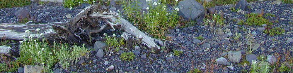
Description: Paved trail with interpretive signs. The trail offers a close-up look at returning life, as well as evidence from the 1980 blast and views of Mount St. Helens, Coldwater Lake, and Maratta Pond.
Birth of a Lake Trail #246 -- Access at Coldwater Lake Recreation Area.
Trailhead facilities: Restrooms, drinking water, telephones and picnic area.
Length: 0.25 mile. Difficulty: Easy. No elevation change
Description: Boardwalk with interpretive signs along the shore of Coldwater Lake, a lake created by the 1980 eruption. The trail offers a closeup look at returning life in the area, with glimpses of Mount St. Helens and views of Minnie Peaks.
Eruption Trail #201 (not shown on map), Access at Johnston Ridge Observatory
Trailhead facilities: Restrooms, drinking water, telephones and picnic area
Length: 0.5 miles, 0.8 km. Difficulty: Moderate. Elevation change: 300 feet.
Description: Paved trail with interpretive signs. The trail offers panoramic views of Mount St. Helens' crater, the pumice plain and blast zone, as well as partial views of Sprit Lake.
Easy-Moderate Trails:
Boundary Trail #1, Hummocks Trailhead/Johnston Ridge Observatory
Trailhead facilities: Restrooms, drinking water and telephones are available at Johnston Ridge Observatory.
Length: See map for details. Difficulty: Moderate to difficult. Elevation change: up to 3000 ft 914 m
Description: Boundary Trail #1.5 proceeds up the valley from Hummocks Trail #229 with excellent views of the landslide and Mount St. Helens' crater. From Johnston Ridge Observatory, Boundary Trail #1 gives wide views of the blast zone, with excellent views of the pumice plain and crater to the south, and partial views of Spirit Lake to the east. Near the junction with Coldwater Trail #230-2, Boundary Trail #1 goes through a natural arch with views of Saint Helens Lake and the Mount Margaret Backcountry.
Hummocks Trail #229, Hummocks Trailhead
Trailhead facilities: None. Nearest restrooms, drinking water and phones at Coldwater Lake Recreation Area.
Length: 2.6 miles, 4.3 km. Difficulty: Moderate. Elevation change: 300 ft. 91 m
Description: The trail takes you through hummocks (giant chunks of Mount St. Helens deposited by the May 18, 1980 landslide). It offers a close-up look at numerous wetlands and ponds, as well as excellent views of Mount St. Helens and the Toutle River.
Difficult Trails:
Elk Bench Trail #211D, Coldwater Ridge Visitor Center
Trailhead facilities: Restrooms, drinking water, telephones, food, and picnic area available at Coldwater Ridge Visitor Center
Length: 1.0 mile, 1.6 km. Difficulty: Difficult- Elevation change: 600 ft. 183 m
Description: From Coldwater Ridge Visitor Center, the Elk Bench Trail descends via switchbacks to join Lakes Trail #211 on the shore of Coldwater Lake. The Elk Bench Trail offers views of Mount St. Helens, Coldwater Lake and Minnie Peaks.
Truman Trail #207, Windy Ridge Viewpoint
Trailhead facilities: Restrooms are available at Windy Ridge Viewpoint.
Length: 5.8 miles, 9.7 km. Difficulty: Moderate to difficult. Elevation Change: 1200 ft. 366 m
Description: This trail takes you through the pumice plain, with views of Mount St. Helens' crater, Spirit Lake and Loowit Falls.
Harry's Ridge Trail #208, spur of Boundary Trail #1
Trailhead facilities: None, this trail is accessed by Boundary Trail #1.
Nearest facilities at Johnston Ridge Observatory, 3.1 mi from trailhead.
Length: 1.0 mi., 1.6 km. Difficulty: Moderate to difficult Elevation change: 200 ft. 61 m.
Description: This spur trail climbs Harry's Ridge to offer excellent views of Spirit Lake. Hummocks (giant chunks of Mount St. Helens deposited by the May 18, 1980 landslide) are visible in the northern comers of the lake, and thousands of trees that were swept into the lake during the eruption can still be seen floating on the lake.
Lakes Trail #211, Coldwater Lake Recreation Area
Trailhead facilities: Restrooms, drinking water, telephones and picnic
area.
Length: 5.25 miles, 7.0 km. Difficulty: Most difficult. Elevation
change: 2700 feet.
Description: This trail follows the shore of Coldwater Lake. It offers a close-up look at returning life in the area.
South Coldwater Trail #230A, Coldwater Trail #230, Coldwater Trail #230-2, South Coldwater Trailhead
Trailhead facilities: None. Nearest Facilities at Coldwater Lake Recreation Area
Length: See map for details Difficulty: Moderate to difficult Elevation Change: 1300 ft. 396 m
Description: South Coldwater Trail #230A offers views of Coldwater Lake. Blasted logging equipment from 1980 is visible 1.75 mi. up the trail. Coldwater Trails #230 and #230-2 offer views of Mount St. Helens, Coldwater Lake and Coldwater Peak.
Go Northwest!
Bookstore
Best selection of books on the Northwest.
Click here!
 Day
Hiking Mount St. Helens by Craig Romano and Aaron Theison. This
Mountaineers Book features every trail within and around the monument.
Hikes are arranged by regions with trail descriptions, directions to
trailheads and difficulty ratings along with other useful information
and photographs.
Order now...
Day
Hiking Mount St. Helens by Craig Romano and Aaron Theison. This
Mountaineers Book features every trail within and around the monument.
Hikes are arranged by regions with trail descriptions, directions to
trailheads and difficulty ratings along with other useful information
and photographs.
Order now...
 Mount
St. Helens 35th Anniversary Edition: The Eruption and Recovery of a Volcano by Rob Carson.
Along with remarkable before-and-after images, this 35th-anniversary
retrospective captures the human drama leading up to the eruption and two
decades of subsequent scientific research of the amazing post-blast
ecological recovery.
Order now...
Mount
St. Helens 35th Anniversary Edition: The Eruption and Recovery of a Volcano by Rob Carson.
Along with remarkable before-and-after images, this 35th-anniversary
retrospective captures the human drama leading up to the eruption and two
decades of subsequent scientific research of the amazing post-blast
ecological recovery.
Order now...
 A
Falcon Guide to Mount St. Helens: A Guide to Exploring the Great Outdoors
by Fred Barstad. This book is a comprehensive guide to this
world-renowned attraction, with a close-up look at the destruction and
recovery of the area. The guide includes detailed information on
the natural and cultural history of the area, recreational opportunities, and historical, geological, and natural
exhibits.
Order now...
A
Falcon Guide to Mount St. Helens: A Guide to Exploring the Great Outdoors
by Fred Barstad. This book is a comprehensive guide to this
world-renowned attraction, with a close-up look at the destruction and
recovery of the area. The guide includes detailed information on
the natural and cultural history of the area, recreational opportunities, and historical, geological, and natural
exhibits.
Order now...
 Day
Hiking South Cascades (Mountaineers Book) by Dan Nelson. This compact
guide features over 100 day hikes with detailed information, charts,
full-colored maps and historical highlights. Discover where to camp,
extended routes and difficulty ratings on each hike.
Order now...
Day
Hiking South Cascades (Mountaineers Book) by Dan Nelson. This compact
guide features over 100 day hikes with detailed information, charts,
full-colored maps and historical highlights. Discover where to camp,
extended routes and difficulty ratings on each hike.
Order now...
 Eruption:
The Untold Story of Mount St. Helens by Steve Olson. Learn the history
and science of one of the largest eruptions and the effects of the
aftermath through personal stories and accounts of those caught in the
disaster. Illustrations and maps enable a greater understanding of this
tragic event.
Order now...
Eruption:
The Untold Story of Mount St. Helens by Steve Olson. Learn the history
and science of one of the largest eruptions and the effects of the
aftermath through personal stories and accounts of those caught in the
disaster. Illustrations and maps enable a greater understanding of this
tragic event.
Order now...
 In
the Blast Zone: Catastrophe and Renewal on Mount St. Helens by Charles
Goodrich, Kathleen Dean Moore and Frederick Swanson. This book presents a
cross-pollination of literary and scientific perspectives on the mountain's
history of cataclysm and renewal. Discover the gifts of beauty, scientific illumination
and of hope.
Order now...
In
the Blast Zone: Catastrophe and Renewal on Mount St. Helens by Charles
Goodrich, Kathleen Dean Moore and Frederick Swanson. This book presents a
cross-pollination of literary and scientific perspectives on the mountain's
history of cataclysm and renewal. Discover the gifts of beauty, scientific illumination
and of hope.
Order now...
 Portrait
of Mount St. Helens: A Changing Landscape by Chuck Williams (Author) and
Stuart Warren (Contributor). View the grandeur and the intimate detail of
this beloved mountain as seen by 19th-century painters and pioneers as well
as contemporary photographers.
Order now...
Portrait
of Mount St. Helens: A Changing Landscape by Chuck Williams (Author) and
Stuart Warren (Contributor). View the grandeur and the intimate detail of
this beloved mountain as seen by 19th-century painters and pioneers as well
as contemporary photographers.
Order now...
We appreciate your orders. They help keep
Go Northwest! online.
Northwest Books
from . . .
![]()
Shopping at
Go Northwest!
![]()
![]()
![]()
![]()