![]()
![]()
![]()
![]()
Back to
North Central MT
main page
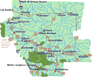
The city and highway map of North Central Montana will help you locate cities, towns and major highways.
Cities and Towns of North Central Montana
Choteau
Conrad
Dupuyer
Fort Benton
Great Falls
Havre
Lewistown
Martinsdale
Utica
Lewis and Clark National Historic Trail Interpretive Center
More Montana
ACTIVITIES
Snow Skiing
Tours
Tour Operators
Whitewater Rafting
VISITOR INFORMATION
Cities and Towns
Map of Montana
Montana Travel Regions and Maps:
Map
North Central
Map
Northeast
Map
Northwest
Map
South Central
Map
Southeast
Map
Southwest
More Maps
British Columbia
Idaho
Montana
Oregon
Washington
North Central Montana: Russell Country
Relief Map
The relief map of North Central Montana will help you locate geographical features such as rivers and mountains.
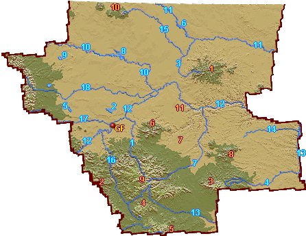
| GF | Great Falls | 1 | Belt Creek | ||
| 1 | Bears Paw Mountains | 2 | Benton Lake | ||
| 2 | Big Belt Mountains | 3 | Big Sandy Creek | ||
| 3 | Big Snowy Mountains | 4 | Flat Willow Creek | ||
| 4 | Castle Mountains | 5 | Freezeout Lake | ||
| 5 | Crazy Mountains | 6 | Fresno Reservoir | ||
| 6 | Highwood Mountains | 7 | Judith River | ||
| 7 | Judith Basin | 8 | Lake Elwell | ||
| 8 | Judith Mountains | 9 | Lake Frances | ||
| 9 | Little Belt Mountains | 10 | Marias River | ||
| 10 | Sweet Grass Hills | 11 | Milk River | ||
| 11 | White Cliffs Area | 12 | Missouri River | ||
| 13 | Musselshell River | ||||
| 14 | Sacagawea River | ||||
| 15 | Sage Creek | ||||
| 16 | Smith River | ||||
| 17 | Sun River | ||||
| 18 | Teton River |
Go Northwest!
Bookstore
Best selection of books on the Northwest.
Click
here!
 Benchmark
Montana Road & Recreation Atlas by Benchmark Maps. Large-scale Landscape
MapsTM and a complete 30-page Recreation Guide make it the ideal planning
tool for any outdoor adventure. Benchmark field-checkers drove thousands of
miles to make sure the Montana Road & Recreation Atlas is the most accurate
and reliable map product.
Order now...
Benchmark
Montana Road & Recreation Atlas by Benchmark Maps. Large-scale Landscape
MapsTM and a complete 30-page Recreation Guide make it the ideal planning
tool for any outdoor adventure. Benchmark field-checkers drove thousands of
miles to make sure the Montana Road & Recreation Atlas is the most accurate
and reliable map product.
Order now...
 Montana River Maps & Fishing Guide by Ray Rychnovsky, Author/Editor and Esther
Poleo, Illustrator. Features the best 30 Montana rivers. Included for each
river are the best seasons, species, available illustrated fishing methods
(both fly and gear), best flies and best gear for individual rivers and
species and more.
Order now...
Montana River Maps & Fishing Guide by Ray Rychnovsky, Author/Editor and Esther
Poleo, Illustrator. Features the best 30 Montana rivers. Included for each
river are the best seasons, species, available illustrated fishing methods
(both fly and gear), best flies and best gear for individual rivers and
species and more.
Order now...
 Montana's Historical Highway Markers by Jon Axline and Glenda Clay
Bradshaw. Discover Montana's history by the roadside markers and signs.
This book has historic photos and easy to follow maps to the signs
locations. Learn the stories of the people of Montana.
Order now...
Montana's Historical Highway Markers by Jon Axline and Glenda Clay
Bradshaw. Discover Montana's history by the roadside markers and signs.
This book has historic photos and easy to follow maps to the signs
locations. Learn the stories of the people of Montana.
Order now...
 Scenic Routes & Byways Montana, 3rd
Edition by S. A. Snyder. Explore scenic byways and backroads, trails, beautiful areas, ghost towns, hot springs
and glaciers. This book provides itineraries, route maps, detailed descriptions of attractions plus many more tips and trips.
Order now...
Scenic Routes & Byways Montana, 3rd
Edition by S. A. Snyder. Explore scenic byways and backroads, trails, beautiful areas, ghost towns, hot springs
and glaciers. This book provides itineraries, route maps, detailed descriptions of attractions plus many more tips and trips.
Order now...
 Backroads
& Byways of Montana: Drives, Day Trips & Weekend Excursions, 2nd Edition
by Jeff Welsch and Sherry L. Moore. Explore the scenic landscapes and
charming towns of Big Sky Country. Itineraries and tips plus color
photos enable to the traveler to plan a short or long trip.
Order now...
Backroads
& Byways of Montana: Drives, Day Trips & Weekend Excursions, 2nd Edition
by Jeff Welsch and Sherry L. Moore. Explore the scenic landscapes and
charming towns of Big Sky Country. Itineraries and tips plus color
photos enable to the traveler to plan a short or long trip.
Order now...
We appreciate your orders. They help keep
Go Northwest! online.
Northwest Books
from . . .
![]()
Shopping at
Go Northwest!
![]()
![]()
![]()
![]()