![]()
![]()
![]()
![]()
Back to
Mount Rainier NP
main page
More Mount Rainier
Description of Park
History of Park
Map of Area
Map of Park
Rainier the Mountain
Links
Nearby Cities and Towns
Ashford, 23 miles
Auburn, 62 miles
Buckley, 59 miles
Crystal Mountain, 46 miles
Eatonville, 44 miles
Elbe, 31 miles
Enumclaw, 63 miles
Greenwater, 19 miles
Mineral, 19 miles
Morton, 30 miles
Packwood, 29 miles
Randle, 48 miles
Tacoma, 60 miles
Yakima, 74 miles
More
Volcanoes
More Cascades
North Cascades
Central Cascades
South Cascades
Washington Travel Regions and Maps
Map
Cascade Mountains
Map
Northeast
Map
Northwest
Map
Olympic Peninsula
Map
Puget Sound
Map
San Juan Islands
Map
South Central
Map
Southeast
Map
Southwest
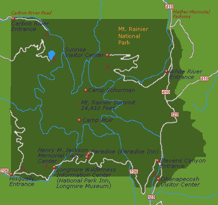
Map of Park Key Features
This Mount Rainier National Park map shows key features including the location of visitor centers, information centers, campgrounds and entrances to Mount Rainier National Park.
To locate cities and towns near the park, see our Mount Rainier Area Map page.
![]() Campgrounds
Campgrounds
Go Northwest!
Bookstore
Best selection of books on the Northwest.
Click here!
 The
Measure of a Mountain: Beauty and Terror on Mount Rainier by Bruce
Barcott. Mount Rainier, North America's biggest volcano, looms over Seattle
like an invitation to... adventure? Disaster? Discovery? It's all of the
above for Bruce Barcott, a Seattle writer who captures the mountain from
multiple angles in this luminous biography that defines Rainier's landscape
to be like none other on the continent.
Order now...
The
Measure of a Mountain: Beauty and Terror on Mount Rainier by Bruce
Barcott. Mount Rainier, North America's biggest volcano, looms over Seattle
like an invitation to... adventure? Disaster? Discovery? It's all of the
above for Bruce Barcott, a Seattle writer who captures the mountain from
multiple angles in this luminous biography that defines Rainier's landscape
to be like none other on the continent.
Order now...
 Mountaineering:
Freedom of the Hills: 50th Anniversary by The Mountaineers. From choosing
equipment to tying a climbing knot, from basic rappelling techniques to
planning an expedition, it is all here in this mountaineering reference. A
team of experts, all active climbers and climbing educators, reviewed,
revised, and updated this compendium to reflect the latest in mountaineering
equipment and techniques.
Order now...
Mountaineering:
Freedom of the Hills: 50th Anniversary by The Mountaineers. From choosing
equipment to tying a climbing knot, from basic rappelling techniques to
planning an expedition, it is all here in this mountaineering reference. A
team of experts, all active climbers and climbing educators, reviewed,
revised, and updated this compendium to reflect the latest in mountaineering
equipment and techniques.
Order now...
 Washington's
Mount Rainier National Park: A Centennial Celebration by Tim McNulty and
Pat O'Hara. In this official book, O'Hara and McNulty view the mountain
through all its facets: from the geologic and climatic forces that continue
to shape it, the rich legacy of humans' relationship with it and its
delicate ecosystems.
Order now...
Washington's
Mount Rainier National Park: A Centennial Celebration by Tim McNulty and
Pat O'Hara. In this official book, O'Hara and McNulty view the mountain
through all its facets: from the geologic and climatic forces that continue
to shape it, the rich legacy of humans' relationship with it and its
delicate ecosystems.
Order now...
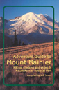 Adventure
Guide to Mount Rainier: Hiking, Climbing and Skiing in Mt. Rainier National
Park by Jeff Smoot. Includes descriptions of tourist trails, nature
trails, off-trail hiking, bike routes, minor peak scrambling, skiing and
snowshoeing areas, and of course, summit routes.
Order now...
Adventure
Guide to Mount Rainier: Hiking, Climbing and Skiing in Mt. Rainier National
Park by Jeff Smoot. Includes descriptions of tourist trails, nature
trails, off-trail hiking, bike routes, minor peak scrambling, skiing and
snowshoeing areas, and of course, summit routes.
Order now...
We appreciate your orders. They help keep
Go Northwest! online.
Northwest Books
from . . .
![]()
Shopping at
Go Northwest!
![]()
![]()
![]()
![]()