![]()
![]()
![]()
![]()
Back to
Northwest MT
main page
Visit the Communities of the Bitterroot Valley
Darby
Florence
Hamilton
Lolo
Stevensville
Sula
Victor
Cities and Towns of Northwest Montana
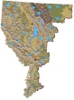
The relief map of Northwest Montana will help you locate geographical features such as rivers and mountains.
More Northwest Montana
Bitterroot Valley
Blackfeet Indian Res.
Clark Fork River
Flathead Valley
Kootenai Valley
Missoula Valley
Seeley Swan Valley
More Montana
ACTIVITIES
Snow Skiing
Tours
Tour Operators
Whitewater Rafting
VISITOR INFORMATION
Cities and Towns
Map of Montana
Montana Travel Regions and Maps:
Map
North Central
Map
Northeast
Map
Northwest
Map
South Central
Map
Southeast
Map
Southwest
Bitterroot Valley
The Bitterroot Valley, one of the major north-south valleys of Northwest Montana, stretches south from Missoula and I-90 some 95 miles to the Idaho Border at Lost Trail Pass.
The principal thoroughfare is US Highway 93, a major route that runs from its northern extremity at the US and Canadian border to its southern extremity in southwest Arizona. The route follows the Bitterroot River, the dominant natural feature within the valley, and connects the cities and towns of the valley much as the river did when those settlements were first established in the late 1800's.
A secondary highway, which is much less busy and thus provides a more leisurely route for the sightseeing traveler, is the East Side Highway (MT 269) between Stevensville and Hamilton. This route presents better views of the Bitterroot Mountains as well as offering a more relaxing drive.
Surrounding the valley, much like the claw of a crab, is the Bitterroot National Forest which carpets the two mountain ranges on either side of the valley and connects and closes in upon the narrowing valley at its south end.
The lower Bitterroot Valley, that part from Missoula to Hamilton, is wider, flatter and more open and is said to be the oldest continuously inhabited area of Montana. Watch for old homesteads and solitary apple trees that mark the locations of what were once extensive orchards. Today, these lands are giving way to subdivisions that signal the growth and popularity of this beautiful valley.
Driving US 93 from Missoula, the traveler to Hamilton will see miles of highway lined with construction yards sporting new log houses in all sizes and stages of construction. Perhaps it's the rugged outdoor flavor of these soon-to-be homes, the beautiful valley, and the promise of realized dreams that has prompted growth so rampant that some say it could turn the lower Bitterroot Valley into the kind of congestion that many had hoped to leave behind.
The upper Bitterroot Valley, from Hamilton to Lost Trail Pass at the Idaho border, grows more narrow as you travel south as the mountain slopes and forest close in on the highway to form the apex of the valley.
Hamilton, the county seat of Ravalli County, is the largest of the cities with a population a little more than 4,000 people. Other communities include Conner, Darby, Stevensville, Sula and Victor.
Each of these communities lies within close proximity to the Bitterroot River and within the shadows of the towering mountain ranges that rise on either side of the valley. To the east are the Sapphire Mountains; lightly forested, drier and more rounded as compared to the neighboring range to the west, the Bitterroot Mountains. The Bitterroots present a formidable barrier to westward penetration in that they are heavily forested, with rockier and steeper peaks and deep craggy canyons.
The Kootenai, Nez Perce, Salish and other Native American tribes, often traveled or lived in the valley from time to time. The valley also was on the route chosen by the Lewis and Clark Expedition of 1805-06 and was along the path taken by the non-treaty Nez Perce during the Nez Perce War of 1877.
Today, the valley, its communities and the surrounding mountains and forests offer an abundance of outdoor recreational opportunities including camping, fishing, hiking, backpacking, horse pack trips, and hunting. The valley is peppered with bed and breakfast accommodations, campgrounds, ranches, guides and outfitters.
Related Sites
Ravalli Republic. 232 W. Main, Hamilton, Montana 59840. Phone: 406-363-3300.
Go Northwest!
Bookstore
Best selection of books on the Northwest.
Click
here!
 Moon Montana,
9th Edition (Moon Handbooks) by Judy Jewell and W.C. McRae. This guide
has complete information about all of Big Sky Country, from Yellowstone
National Park to the eastern prairies of the state, to help the traveler
plan a memorable vacation.
Order now...
Moon Montana,
9th Edition (Moon Handbooks) by Judy Jewell and W.C. McRae. This guide
has complete information about all of Big Sky Country, from Yellowstone
National Park to the eastern prairies of the state, to help the traveler
plan a memorable vacation.
Order now...
 Scenic Routes & Byways Montana, 3rd
Edition by S. A. Snyder. Explore scenic byways and backroads, trails, beautiful areas, ghost towns, hot springs
and glaciers. This book provides itineraries, route maps, detailed descriptions of attractions plus many more tips and trips.
Order now...
Scenic Routes & Byways Montana, 3rd
Edition by S. A. Snyder. Explore scenic byways and backroads, trails, beautiful areas, ghost towns, hot springs
and glaciers. This book provides itineraries, route maps, detailed descriptions of attractions plus many more tips and trips.
Order now...
 Montana
Off the Beaten Path, 9th Edition: A Guide to Unique Places by Ednor
Therriault and Michael McCoy. Discover hidden attractions, unusual
locales, unique finds and quirky cultural tidbits; all the interesting
stuff you'd want to see and experience if you only knew about them.
Order now...
Montana
Off the Beaten Path, 9th Edition: A Guide to Unique Places by Ednor
Therriault and Michael McCoy. Discover hidden attractions, unusual
locales, unique finds and quirky cultural tidbits; all the interesting
stuff you'd want to see and experience if you only knew about them.
Order now...
 Benchmark
Montana Road & Recreation Atlas by Benchmark Maps. Large-scale Landscape
MapsTM and a complete 30-page Recreation Guide make it the ideal planning
tool for any outdoor adventure. Benchmark field-checkers drove thousands of
miles to make sure the Montana Road & Recreation Atlas is the most accurate
and reliable map product.
Order now...
Benchmark
Montana Road & Recreation Atlas by Benchmark Maps. Large-scale Landscape
MapsTM and a complete 30-page Recreation Guide make it the ideal planning
tool for any outdoor adventure. Benchmark field-checkers drove thousands of
miles to make sure the Montana Road & Recreation Atlas is the most accurate
and reliable map product.
Order now...
 Northwest
Montana Fire Lookouts...A Hiking Guide by Steve Rains, Blake Passmore,
Lynne Rains and Calab Rains. This guide takes the hiker to 30 lookouts
expanding over 6 mountain ranges. Get details on trailhead directions,
routes, safety and photographs. For more info see
http://letshikemontana.com
Order now...
Northwest
Montana Fire Lookouts...A Hiking Guide by Steve Rains, Blake Passmore,
Lynne Rains and Calab Rains. This guide takes the hiker to 30 lookouts
expanding over 6 mountain ranges. Get details on trailhead directions,
routes, safety and photographs. For more info see
http://letshikemontana.com
Order now...
 Great
Places: Montana: A Recreational Guide to Montana's Public Lands and Historical Places for Birding, Hiking, Photography, Fishing, Hunting
by Chuck Robbins. Recreational guide to Montana's public lands and historical places. There are maps and
photos and a contact list with web sites, addresses and phone numbers of all of the public areas.
Also a complete bird list for
all of Montana.
Order now...
Great
Places: Montana: A Recreational Guide to Montana's Public Lands and Historical Places for Birding, Hiking, Photography, Fishing, Hunting
by Chuck Robbins. Recreational guide to Montana's public lands and historical places. There are maps and
photos and a contact list with web sites, addresses and phone numbers of all of the public areas.
Also a complete bird list for
all of Montana.
Order now...
We appreciate your orders. They help keep
Go Northwest! online.
Northwest Books
from . . .
![]()
Shopping at
Go Northwest!
![]()
![]()
![]()
![]()